-
Enterprise
 Premium Parcels
 Roadway ROW
- Data Store
- Regrid App
- Esri Users
-
Resources
 Support
 Content
 Programs
.png) Shop
Shop
- Contact Us
- Hide Menu


In addition to high quality, standardized nationwide parcel data, we have put together contextual, standardized nationwide land use codes as part of our premium data package. These codes will help you get the nuanced context on land use for your projects.
From community and urban planning, to site selection, to understanding what activity is allowed on a particular piece of land, and to commercial real estate, the use cases are endless & Landgrid’s standardized use codes have you covered.
Data driven decisions and faster time to market for your projects!
What we offer
We offer standardized land use information for 5 dimensions:
-
Activity describes the actual activity & use of the property such as "Residential" or "Restaurant-type activity" or "Power transmission lines" or "control activities" or "Hunting" and the list goes on.
-
Function describes the broader economic or social use of the parcel such as "Alternative energy sources" or "Agriculture, forestry, fishing and hunting" or "Commercial property-related or Private household" or "Cafeteria or limited service restaurant" or "Hydroelectric"…
-
Structure describes the type of structure & building on the parcel. Examples include "single family buildings", "types of multi-unit buildings - 3 units, 11 units" etc, "detached units", "Office building over storefronts" etc.
-
Site describes the physical characteristics of a site or land. For example, "Developed site — crops, grazing, forestry, etc." or "State, national, or other parks and recreational sites etc."
-
Ownership mainly describes if it's publicly or privately owned land. "Private property" or publicly owned by the local government, county and or non-profit organizations etc. We are currently in the process of developing and populating this field all through 2021.
We derived inspiration from the American Planning Association (APA) and used their Land Based Classification System (LBCS) codes as the guidelines to populate our standardized land-use codes. We applied the LBCS guidelines to the diverse data that we receive from county & designated public sources such as use codes, use description, zoning, ownership and our premium derivative columns to weave them into a standardized use classification system at a nationwide scale.
You can find the descriptions of each one of our land use codes across all 5 dimensions here.
In the top 50 metro areas in the country, we currently have over 80% coverage for the two main land use code dimensions - Activity & Function. Over 2/3rds of our entire nationwide dataset has standardized land use codes at this time and growing as we speak. We continually add new places and fill in codes for existing ones. You can stay up to date on which places have standardized land use codes using the Landgrid coverage report.
Why is this valuable
Local parcel data & property information does not use a widely adopted or standardized use code system. If there is any information pertaining to how a parcel is used, it usually takes the form of local zoning, land use, or tax assessors' codes.
There isn’t any one universal format for standardized land use codes. Because this data varies by the county, Landgrid’s nationwide standardized classification becomes a one stop-solution that makes it easy for anyone who works with our parcel data to make use of nuanced contextual land use information.
It’s also important to note that to weave these land use codes in a standardized format means continuous improvement cycles of multiple rounds of manual review & QC’ing of these codes at our end.
What does this help you with?
Data driven decisions and faster time to market for your projects!
Our parcel data will be your one turn-key solution for all of your contextual property data needs.
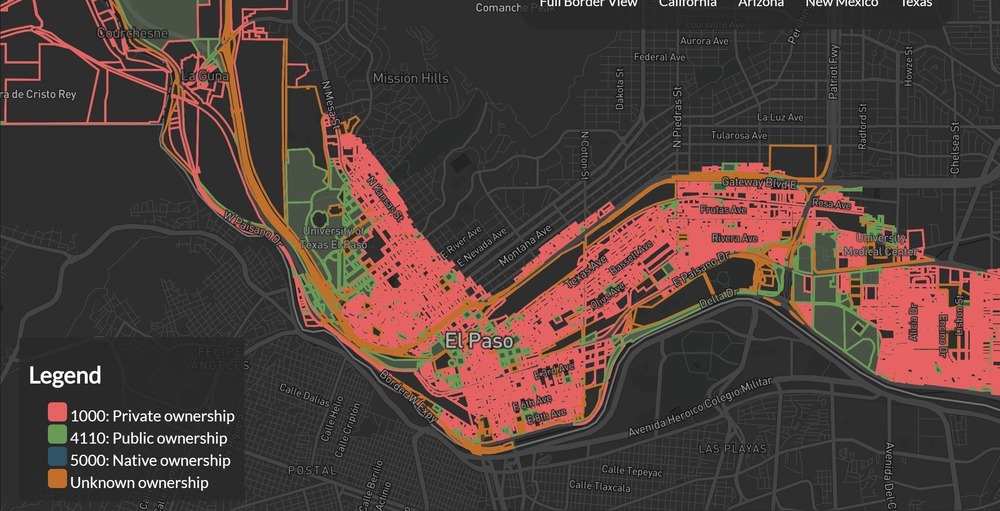
We earlier mentioned that the use cases for land use codes are endless. At Loveland, we use our standardized land use codes for property data analyses for various use cases too. Our recent study on land along the US-Mexico border is a good practical use case on using land use codes to derive more context into property ownership & use along the border.
How to get it
Get our standardized land use code attributes as part of our premium data package along with our other premium derivative fields via bulk data, API, Landgrid Pro, Landgrid Team & Landgrid Enterprise subscriptions.
Premium data includes nationwide parcel boundaries with all basic and standard attributes, plus a variety of fields we append to the data from other sources such as:
- Standardized land use codes
- Nationwide United States Postal Service-validated address data with uniform residential property indicator and vacancy information
- Nationwide building footprint counts and building footprint square footage
How do our customers use our land use codes?
We have seen very many usecases that our customers use our land use codes for - mostly with usecases that need to differentiate between commercial and residential, commercial or industrial etc.
Many of them use it as an alternative for zoning & use description for a property since those don't always come populated from county sources or are not standardized at scale.
"Pivvot uses Loveland's LBCS Columns for customers who need detailed zoning & land use information. Often, the data in these columns are not included in parcel data & county level data. The LBCS columns have been an efficient alternative to missing source data and provide value to our customers."
- Pete Veenstra, Director - Data Architecture at Pivvot

How else can we help you?
In addition to providing amazing parcel data, our talented team makes great GIS software and apps. Make sure you check out our own parcel viewer, Pro software, and free Landgrid mobile app. We customize this software for clients through our whitelabel Enterprise product. We also partner with parcel-level machine learning and predictive analytics companies if you need additional analysis.
Email parcels@landgrid.com or call us at 313-649-LAND for a quote and a data sample