


How Do Michigan's Parcels Work?
By David Mieksztyn on April 2, 2015
When gathering every single parcel possible and putting it into the LOVELAND Explorer, sometimes you need to gather a few people (or an entire state) around a table. Several states already have either a fully developed statewide parcel data layer (New Jersey, Montana), or are presently curating and offering informational resources towards statewide standardization (New York, Massachusetts). LOVELAND thus turned its attention towards its own local home state of Michigan.
LOVELAND partnered with a group of students from the University of Michigan's Social Venture Fund (SVF) at the Stephen M. Ross School of Business to conduct a survey of Michigan's parcel data accessibility, cost structures and overall maintenance practices. Along with support from Michigan's Office of Technology Partnerships (OTP), SVF students administered an online survey to county assessors, GIS departments, and vendors who maintain parcel spatial data for Michigan counties and municipalities.
The results are linked below in a pdf. The hope is to continue on with this preliminary step and bring action within Michigan towards creating a free, accessible and well maintained parcel dataset of all properties within the state.
Report: University of Michigan Social Venture Fund Winter 2015 Loveland Capacity Building Project
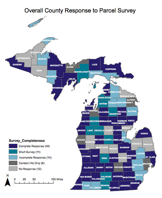
The survey questions are as follows and the report includes 34 maps to illustrate the answers across all 83 counties in Michigan:
• Overall County Response to Parcel Survey
• Who Maintains Parcel Shape Objects? (Showing "County" only)
• Does The County Maintain Digital or Manual Parcels?
• Which Department Maintains Parcel Shape Objects?
• How Often are Parcel Shape Objects Updated?
• If County Maintains Assessment Data, How Often is Data Updated?
• If Cities and Townships Maintain Assessment Data, How Often Does County Recieve Updated Assessment Data?
• Can County Attach Assesment Data to Parcel Shape Objects?
• Is There a County-Wide Complete Parcel Data File?
• Does the County Maintain Parcel Metadata in Conjunction with Parcel Shape Objects?
• How Often is Metadata Updated or Reviewed for Accuracy?
• Can the Public Access Parcel Shape Objects?
• Can the Public Access Assessment Data?
• Can the Public Access Complete Parcel Data?
• What is the Cost of County-Wide Parcel Shape Objects?
• What is the Cost of County-Wide Complete Parcel Data?
• What is the Cost of County-Wide Assessment Data?
• Is There a Cost for an Annual, County-Wide Data Update?
• Is There a Cost for a Bi-Annual, County-Wide Data Update?
• On Average, How Many Sales are Made Per Year of Complete Parcel Data?
• On Average, How Many Sales are Made Per Year of Parcel Shape Objects?
• On Average, How Many Sales are Made Per Year of Assessment Data Only?
• What was the Total Revenue from Data Sales in 2014?
• On Average, How Many Annual Data Updates Does the County Sell?
• When Was the Current Data Pricing Model Enacted?
• How Often is the County's Data Pricing Reviewed?
• Does the County Provide Free Data Access to Certain Groups?
• Does a Vendor Collect and/or Maintain Parcel Shape Objects?
• Does a Vendor Collect and/or Maintain Assessment Data?
• Which Company Provides Online Viewer? (map built from combining survey results with web research)
• Does the County Have an Open Data Policy?
• If the County Does Not Have an Open Data Policy, is the County Currently Working on One?
• To your knowledge, is the county engaged in conversations to participate in the state-wide open data policy?
• Are You Interested in a State-wide Parcel Layer?
Now go read the whole thing! And let us know if you have any questions or ideas at team@makeloveland.com.