


Introducing the 3Cs Mapping Project
By Jerry Paffendorf on April 18, 2017
Loveland is very happy to share the public release of 3csmapping.com, featuring our next generation of city mapping and property dashboards.
The 3Cs project is a partnership with the Western Reserve Land Conservancy and JPMorgan Chase to provide community mapping and surveying tools for Cleveland, Cincinnati, and Columbus, Ohio. It is also a partnership with a growing number of local organizations who are using and contributing to the data.
Visit 3csmapping.com to jump right in, or press play on the video and scroll down for an overview.
Here's a quick walkthrough of the new superpowers on the site:
1. Explore the maps
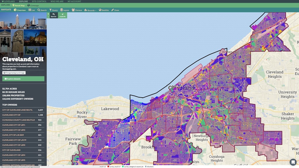
Click around the maps to see parcel-level data for cities and neighborhoods, including property ownership, zoning, sale prices, and taxes. Click "Explore datasets" to open up a panel with additional datasets for each city. Click "Add to Map" to visualize the dataset. Click Query to further filter the data on the map.
Here's a great example, visualizing the citywide property survey of Cleveland conducted by the Western Reserve Land Conservancy with the
Loveland Survey App: https://cleveland.makeloveland.com/#b=neighborhoods&d=934
2. Add your own data
If you have a spreadsheet with an address, parcel ID, or latitude-longitude column, you can easily visualize it on the map and share it with other people. Click "Explore datasets" and then click "Add your own data." From there you simply import your file and then give it a name, description, and credit the source. It's never been easier to make and share awesome maps. We're signing up data partners in each city who want to help find and update new information. If you're interested, or if you need data that's not currently on the map, please email team@makeloveland.com.

3. Survey properties
Download the Loveland Survey App for iPhone or Android to photograph to photograph and survey properties from the field. Each city starts with a Sandbox Survey where you can test out sending pictures and information to the public map. Watch out for official citywide and neighborhood surveys, and if you want to start your own public survey, email team@makeloveland.com.

But wait. Are you one of the 96 out of 100 Americans who doesn't live in the great state of Ohio? Would you like to see these kinds of mapping capabilities in your city or state? Let us know. We're looking for a few more cities (or towns or counties or states) to work with this year. You can reach us at team@makeloveland.com.
All the best from Detroit, land of enchantment (with all due respect to New Mexico),
Team LOVELAND
313-649-5263 (LAND)
407 E Fort St, Suite 100
Detroit, MI 48226