


Introducing Nationwide Residential & Vacancy Data on Landgrid.com
By Sahana Murthy on September 3, 2019 · Announcements
We’ve got a big new update for you. Like, a REALLY BIG one!!!

Launching today, Nationwide USPS Residential & Vacancy Data!
We have integrated a powerful nationwide vacancy dataset from the United States Postal Service.
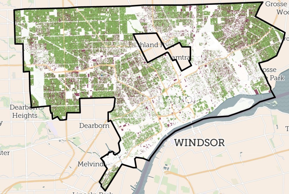
Now you can easily see vacant properties of any zoning type in any neighborhood or city, as well as all residential properties regardless of vacancy.
We've built this powerful dataset from United States Postal Service data, and we'll be updating it frequently throughout the year.
The data is available on our platform right now for Pro and Enterprise customers, so you can visit landgrid.com to check it out. If you don't have a Pro account yet you can sign up here. The data can also be licensed for use outside of our website in your own app or database.
We're excited to provide this vacancy data nationwide at the parcel level, something that to our knowledge has not been done before. While aggregated USPS vacancy data is a widely-accepted indicator and has been used in academic studies and research since at least 2010, there has rarely been a way to crack that data open and see how those aggregations have been made, or how reliable the data is.
While we know that the data is not perfect - and we hope that you get in touch with us to share your findings, so we can refine this dataset going forward - the Loveland team feels that this is an important tool for our friends and partners to have, and a revolutionary step forward in understanding the property dynamics in our communities.
Visit the USPS data page on our website or read on below - https://landgrid.com/vacancy
What does this mean for each one of our solutions, you ask???
Landgrid Mapping Platform - Pro & Enterprise
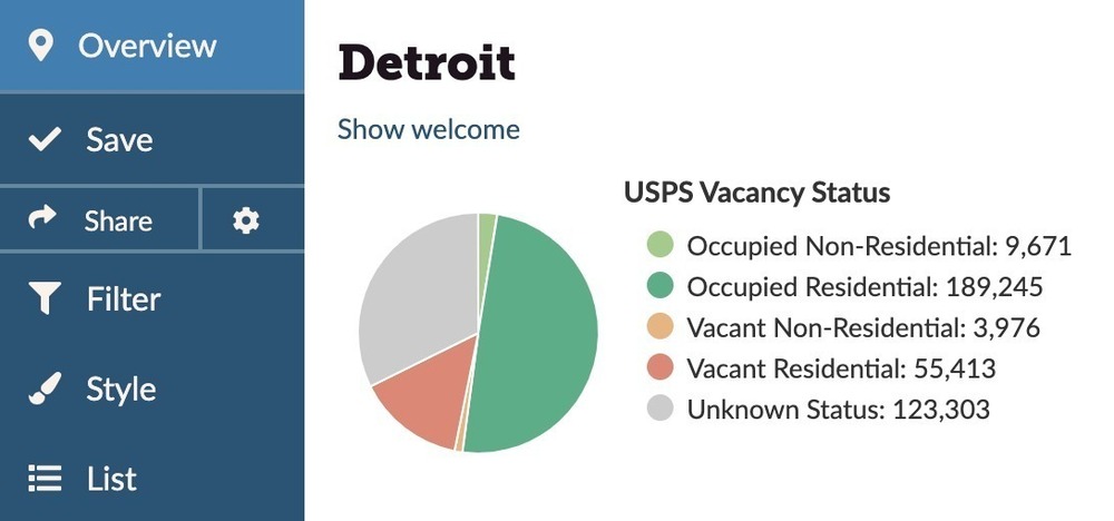
If you’re a Pro or Enterprise member of landgrid.com you now have an easy way to see all residential parcels, nationwide, as well as an indicator of vacancy across all parcels that have buildings, whether they’re residential, commercial, or industrial.
This is data we’ve cleaned, organized, and integrated from the US Postal Service to make it our own and bring it to life for you with our other parcel data.
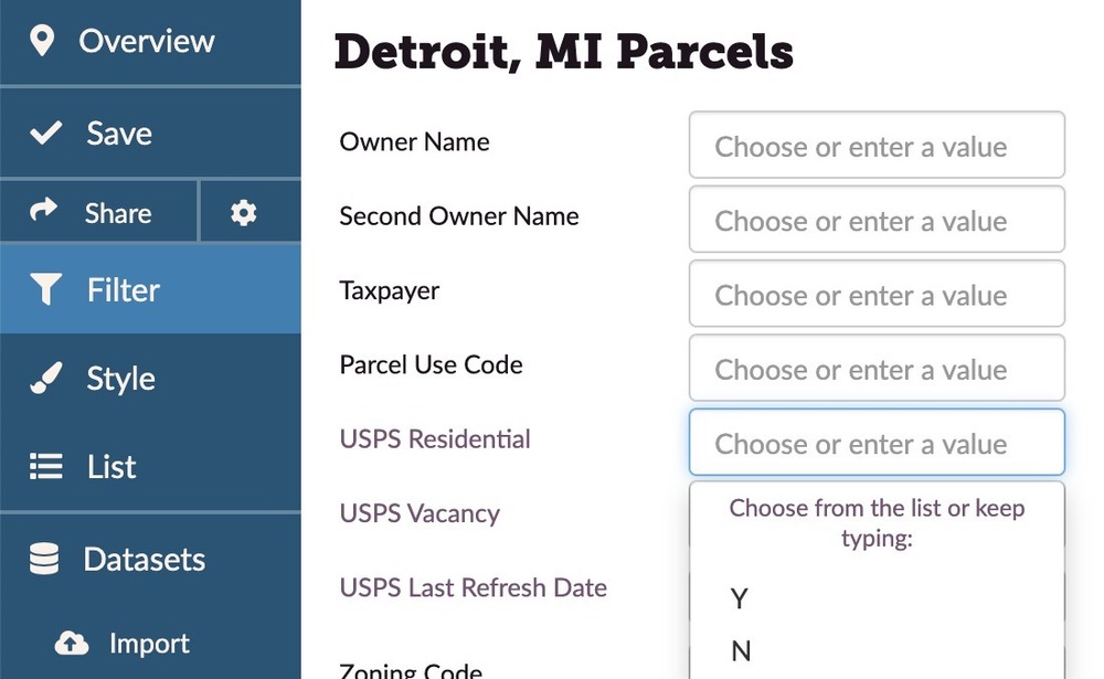
It means that you can now go to your city or the places you’re interested in and use the Filter function to show all residential properties and/or Filter to show all vacant buildings, alone or in combination with any other characteristic you’re looking for.
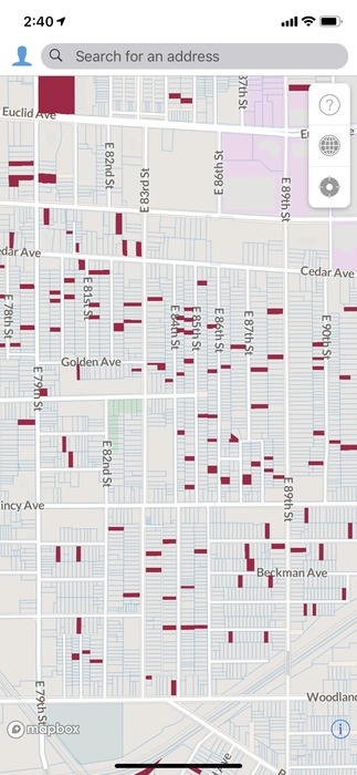
Surveying Vacant Properties with the Landgrid App:
And for those of you who work on tracking and addressing vacant property in your cities, you can now load the vacant properties into a survey so you can quickly visit and document them in the field.
Check out our USPS Data Page to learn how to load vacant properties onto your app for surveying -
https://landgrid.com/vacancy & https://support.landgrid.com/articles/usps-data/
This is all now completely live on landgrid.com, and we’re excited to show it off at the upcoming Ohio Land Bank Conference in Cincinnati where our CEO, Jerry Paffendorf, will be giving a keynote presentation, and at the Center for Community Progress’ Reclaiming Vacant Property Conference in Atlanta where Jerry will be on a panel.
If you don’t have a Landgrid Pro account yet you can sign up here for only $10/month or $100/year.
If you or your organization are working on a project that needs support, multiple users, or custom work from our team, check out our Enterprise offerings here which typically range from $10,000 and up depending on your needs.
Landgrid Parcel Data:
This data can also be licensed for use in your own system along with our other nationwide parcel data. Write to us at parcels@landgrid.com if you are interested.
Note: All data has limitations and imperfections, but this is an incredible dataset for you to make use of. So please be aware that there might be some discrepancies with this data occasionally.
Some of the limitations and imperfections here include not yet being able to match every address to every parcel perfectly; the vacancy indicator may apply to one or a few units within an otherwise occupied multi-unit dwelling; you are asked not to use the data for direct mail commercial marketing campaigns, and the USPS data will not download in a CSV export for Pro customers. (though after you Filter you can export a CSV of those properties minus the USPS column).
Learn more about this data & its limitations here - https://landgrid.com/vacancy
We will be working to ground-truth and improve the accuracy of this data moving forward. If you have observations about the USPS data in your area which you'd like to share with us in an effort to refine and improve the information, please contact Nick: nick@landgrid.com.
Those things aside and in mind, this is a huge leap for parcel-kind!
While standardized nationwide zoning is hard, you now have a uniform nationwide indicator of what is residential (alongside of the other local zoning information we have). Similarly, while understanding nationwide vacancy is hard, you now have an out-of-the-box solution to understand the scale of potential vacancy and jumpstart your planning processes.
Please parcel responsibly, and reach out to us at team@landgrid.com if we can do anything for you.
Happy Mapping!
Sahana Murthy
GM, Loveland Technologies
sahana@landgrid.com