


Nationwide LBCS - Zoning and Usecode Standardization
By Raven Visser on March 19, 2020 · How-To
While browsing Landgrid's data, you may have encountered fields like "lbcs_activity" and "lbcs_function", but their values are just 4-digit numbers. What exactly do those fields mean? Let's take a quick look!
The Land-Based Classification System (LBCS) is a method devised by the American Planning Association to describe how the land of an individual parcel is used. It encodes land use across five dimensions (activity, function, structure, site, and ownership). These codes are 4-digit numbers, with the first digit denoting the broadest category, and each successive digit describing the parcel in more detail.
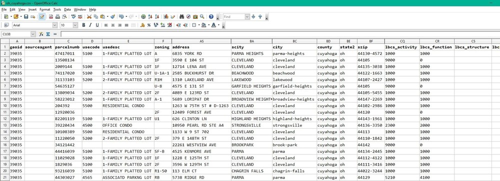
We focus primarily on the "lbcs_activity" and "lbcs_function" dimensions because they make the most sense at the parcel level. Activity describes the actual human activities that take place on the parcel, while function describes the broader economic or social use the parcel serves. For example, a parcel that is used as a parking lot for a school would have an "lbcs_activity" code of "5000" (for "Travel or movement activities"), but an "lbcs_function" code of "6000" (for "Education, public admin., health care, and institutional").
Most parcel data, however, does not use LBCS, and varies widely in how land use is classified (if that information is available at all). If there is any information pertaining to how a parcel is used, it usually takes the form of local zoning, land use, or tax assessors' codes. Because of this inconsistency, our LBCS classification work is done manually, county by county, matching each place's land use or zoning information to the nearest applicable LBCS code.
Currently, in Loveland's dataset of more than 144 million parcels, 54% of parcels have an LBCS code for function, and 45% of parcels have an LBCS code for activity. These percentages are increasing constantly as we add new places and fill in codes for existing ones. You can stay up to date on which places have LBCS data using the Landgrid coverage report.
We're working on implementing additional data fields to provide text description in addition to the LBCS codes. This will do away with the need to cross-reference the 4-digit codes in Landgrid's data with the APA website's master list of codes for each dimension. We hope to have these fields operational sometime in 2020.
The main reason we spend time implementing LBCS in our dataset is its universality. Local zoning, land use, or assessors' codes are still visible on parcels which have that data (usually in the "zoning", "zoning_description", "usecode", or "usedesc" fields, and sometimes in custom fields). But while there is variability from county to county what a zoning value of “101” or “R-1” is, an "lbcs_activity" value of "1000" always means "Residential activities".
This consistency means users of Landgrid's data and the mapping platform can perform queries to find trends across the dataset, or to count certain types of parcels. For instance, a regional business specializing in agricultural equipment could download the data for surrounding counties from the Landgrid data store, and query that data to find the number of parcels in each county with an "lbcs_activity" code in the range 8000-8999, for "natural resources-related activities".This could give a broad overview of places where agricultural activity is more prevalent and could help with focusing sales and marketing efforts where they are more likely to succeed.
Likewise, finding and mapping all the residential parcels in a city could help with understanding and tracking the spread of disease outbreaks like the current COVID-19 pandemic. If you are a local government or a fellow mapping and data company that could use parcel data to push forward your study, outreach efforts and research on COVID-19, or if you have questions about LBCS in general, please contact the Landgrid team at team@landgrid.com, or check out the parcel data FAQ.
Ray Visser
Team Loveland