By Sahana Murthy
on October 8, 2020
· How-To
Dear Friends of Loveland Parcel Data and landgrid.com,
A summary of updates in September of 2020 and the upcoming pipeline is below.
Key Data Stats:
- Total parcel age down by 2.6% from last month
- Average parcel age - 207 days, down from 213 last month
- Average county age - 249 days, up from 240 last month
- ~160K new parcels, 9 new counties added & 236 counties refreshed since last month.
Q3 Update:
- Total # counties refreshed in Q3 2020 - 648
General data update process - We are improving our data set export process over the coming quarter and the first stage is documenting our current method which is below.
Monthly, we update every data tier with the refreshed counties for the month, usually 100 - 300 counties per month.
Monthly, premium attribute data tiers are updated for every county in the data set, because every county's USPS related attributes have been updated for the month.
Quarterly, at the start of the calendar quarter, every data tier will have every county exported. We make improvements to the nationwide data set on a regular basis, often based on feedback from clients. Quarterly, full data set exports ensure every data tier has all of the improvements across the data set, even if the data was not refreshed directly from the county that quarter. We are working to provide an easily sharable change log for data set wide fixes, but currently give a notice to significant updates in our monthly data update emails.
This month's October data set export will be the full Quarterly export for the 4th calendar quarter of 2020, which means every data tier and county has been exported. Please see the 'verse' file for the 'last_refresh' date from the county source for any individual county.
USPS Vacancy, Residential indicators: Now updated monthly. Updated in September 2020, next update in October.
Loveland Parcel Schema - Upcoming changes
Please review the Data Dictionary below for the proposed attribute columns to add. We expect to add the Cropland Data Layer attributes to our Loveland Parcel Schema in October. We also hope to review the needed schema changes for the Census School Districts, which we expect to be 2 - 4 additional attribute columns and get those finalized, but those might be added in November.
Coverage Report: Updated for this month and available here:
https://docs.google.com/spreadsheets/d/1q0PZB72nO8935EMGmsh3864VjEAMUE-pdHcPkoAiS5c/
For all full dataset customers, the updated data is available for download to bulk data clients in these formats: GeoPKG .gpkg (suggested), GeoJSON, Shapefile, and Postgres SQL files. In addition, this data has been updated on the landrid.com website.
If your organization uses a custom export we are updating your data at the moment and if you don’t see the latest updates, please drop us a line.
A Data Dictionary for the Loveland Standard Schema is always available here:
https://docs.google.com/spreadsheets/d/14RcBKyiEGa7q-SR0rFnDHVcovb9uegPJ3sfb3WlNPc0/
A machine-readable version of this list is included in the `verse` table available in all the formats above as well as CSV format for use in spreadsheets. To find the latest updates in verse, sort by 'last_refresh' and use the 'filename_stem' column to identify the file.
Data refreshed or added from the county in September and live now:
( Asterisk * indicates newly added county)
--------------------------------------------------
Alabama - Hale
Illinois - LaSalle, Macoupin, Putnam
Maryland - Allegany, Anne Arundel, Calvert, Caroline, Carroll, Cecil, Charles, Dorchester, Frederick, Harford, Howard, Kent, Queen Anne's, St. Mary's, Talbot, Wicomico, Worcester
Montana - Beaverhead, Big Horn, Blaine, Broadwater, Carbon, Carter, Cascade, Chouteau, Custer, Daniels, Dawson, Deer Lodge, Fallon, Fergus, Flathead, Gallatin, Garfield, Glacier, Golden Valley, Granite, Hill, Jefferson, Judith Basin, Lake, Lewis and Clark, Liberty, Lincoln, Madison, McCone, Meagher, Mineral, Missoula, Musselshell, Park, Petroleum, Phillips, Pondera, Powder River, Powell, Prairie, Ravalli, Richland, Roosevelt, Rosebud, Sanders, Sheridan, Silver Bow, Stillwater, Sweet Grass, Teton, Toole, Treasure, Valley, Wheatland, Wibaux, Yellowstone
South Carolina - Barnwell*, Clarendon*, Lee
Texas - Harris
Virginia - Buckingham
Wisconsin - Milwaukee
In the current pipeline for updating in October 2020
--------------------------------------------------
Virginia
Florida
In the pipeline for updating in November
--------------------------------------------------
Ohio
South Carolina
Based on feedback and county challenges, pipeline planning is always subject to change. As always, please contact us if you have any questions about accessing or using the data, you find issues with any of our data, or you have any comments or questions about our data in specific areas or states. We also love to hear from you about which counties or regions you’d like to see us update next, as it helps inform our planning process.
Thank you for being a part of Loveland!
Happy Mapping!
By Sahana Murthy
on August 10, 2020
· How-To

Dear Friends of Loveland Parcel Data and landgrid.com,
A lot of important information in this one!
A summary of updates in July of 2020 and the upcoming pipeline is below.
Key Data Stats:
- Total parcel age down by 3.5% from last month
- Average parcel age - 196 days, down from 205 last month
- Average county age - 215 days, down from 239 last month
- ~903K new parcels, 71 new counties added & 146 counties refreshed since last month
Land Based Classification System (LBCS) Use Codes update:
We now have over 70% of our parcels with an LBCS code.
Readable LBCS code descriptions - new columns:
Added the description for each code to every parcel.
Shapefile Important Information:
Starting this month we have made the following changes to help flag the counties whose data exceeds the 2GB soft limit. Please double check how you are handling these files.
Duplicate Parcel Records:
We are in the process of identifying and removing about 218,000 truly duplicated parcel records across our dataset. Many counties 'stack' parcels to record multiple owners or multiple units, natural resource rights, etc. These situations are expected and they are still considered good data. As a result, these stacked parcels are not affected.
However, we have found a number of parcel records that are actual duplicates, with nothing unique or different between them in any way aside from the 'll_uuid' we assigned each duplicate record.
We will be removing those in August and exporting the corrected counties (918) in September. About 40 counties account for most of the duplicates, and 800 had less than 1% affected parcels.
We are not sure what caused the issue, but we will put monitoring in place to determine if these are duplicates in the sources or something else is happening to cause them.
USPS Vacancy, Residential indicators:
Now updated monthly. Updated in July 2020, next update in August.
Coverage Report:
Updated for this month and available here:
https://docs.google.com/spreadsheets/d/1q0PZB72nO8935EMGmsh3864VjEAMUE-pdHcPkoAiS5c/
For all full dataset customers, the updated data is available for download to bulk data clients in these formats: GeoPKG .gpkg (suggested), GeoJSON, Shapefile, and Postgres SQL files. In addition, this data has been updated on the landrid.com website.
If your organization uses a custom export we are updating your data at the moment and if you don’t see the latest updates, please drop us a line.
A Data Dictionary for the Loveland Standard Schema is always available here:
https://docs.google.com/spreadsheets/d/14RcBKyiEGa7q-SR0rFnDHVcovb9uegPJ3sfb3WlNPc0/
A machine-readable version of this list is included in the `verse` table available in all the formats above as well as CSV format for use in spreadsheets. To find the latest updates in verse, sort by 'last_refresh' and use the 'filename_stem' column to identify the file.
Data refreshed or added from the county in July and live now:
( Asterisk * indicates newly added county)
--------------------------------------------------
Alabama - Houston
Arizona- Apache, Cochise, Coconino, Gila, Graham, Greenlee, La Paz, Maricopa, Mohave, Navajo, Pima, Pinal, Santa Cruz, Yavapai, Yuma
California - Glenn, Mendocino, San Benito, San Francisco
District of Columbia - Washington
Georgia (55 new counties) - Appling*, Baker*, Banks*, Barrow*, Bleckley*, Butts*, Calhoun*, Candler*, Catoosa*, Chattahoochee*, Chattooga*, Clay*, Clinch*, Colquitt*, Decatur*, Dodge*, Dooly*, Early*, Elbert*, Emanuel*, Franklin*, Glascock*, Hancock*, Harris*, Hart*, Heard*, Jasper*, Jefferson*, Jenkins*, Johnson*, Lamar*, Lanier*, Madison*, Marion*, Meriwether*, Miller*, Montgomery*, Morgan*, Oconee*, Peach*, Pickens*, Pike*, Quitman*, Rabun*, Schley*, Spalding*, Stewart*, Taliaferro*, Tattnall*, Terrell*, Toombs*, Towns*, Treutlen*, Twiggs*, Upson*, Walker*, Walton*, Warren*, Wayne*, Webster*, Wheeler*, Wilkinson*, Worth*, Baldwin, Ben Hill, Brantley, Dade, Evans, Gilmer, Grady, Greene, Laurens, Lee, Lincoln, Long, Lumpkin, Mitchell, Pulaski, Randolph, Rockdale, Seminole, Stephens, Talbot, Taylor, Ware, White, Whitfield
Illinois - Adams, Crawford, DeKalb, Effingham*, Hancock, Lee, Menard, Pike, Sangamon, Tazewell, Whiteside
Indiana - Grant, Porter
Louisiana - Ouachita
Massachusetts - Barnstable, Berkshire, Bristol, Dukes, Essex, Franklin, Hampden, Hampshire, Middlesex, Nantucket, Norfolk, Plymouth, Suffolk, Worcester
Michigan - Allegan, Arenac, Charlevoix, Cheboygan, Eaton, Emmet, Grand Traverse, Ingham, Ionia, Iron, Jackson, Kent, Lapeer, Leelanau, Lenawee, Marquette, Midland, Montcalm, Muskegon, Newaygo, Oceana, Ottawa, Roscommon, Saginaw, St. Clair, Tuscola, Washtenaw
Missouri - Andrew, Atchison, Bates, Benton, Buchanan, Camden, Christian, Cooper, Dallas, Douglas*, Franklin*, Henry, Holt, Laclede*, Lafayette, Lawrence, Lincoln, Linn, Macon*, Miller, Moniteau, Morgan, Phelps, Ralls, Ray, Vernon, Warren
North Dakota - Billings, Bottineau, Bowman*, Burke, Burleigh, Cass, Cavalier, Divide, Dunn, Emmons, Foster*, Golden Valley, Grant, Hettinger, LaMoure, McHenry, McKenzie, McLean, Morton, Mountrail, Nelson*, Pembina, Renville*, Richland, Rolette, Sargent*, Sheridan*, Sioux, Stark, Steele, Traill, Walsh, Ward, Williams
Nebraska - Arthur, Box Butte
New York - Cortland, Genesee, Madison*, Tioga
Oklahoma - Pottawatomie*
Oregon - Columbia, Umatilla
Pennsylvania - Indiana*, Union, Venango*
South Dakota - Aurora, Beadle, Bennett, Bon Homme, Buffalo, Campbell, Clark, Codington, Custer, Davison, Day, Deuel, Douglas, Edmunds, Fall River, Faulk, Grant, Gregory, Hamlin, Hanson, Hutchinson, Jackson, Jerauld, Jones, Kingsbury, Lake, Lawrence, Lincoln, Lyman, Marshall, McPherson, Meade, Mellette, Miner, Minnehaha, Moody, Oglala Lakota, Pennington, Roberts, Sanborn, Tripp, Union, Yankton
Tennessee - Shelby
Texas - Ochiltree
Wisconsin - Adams, Ashland, Barron, Bayfield, Brown, Buffalo, Burnett, Calumet, Chippewa, Clark, Columbia, Crawford, Dane, Dodge, Door, Douglas, Dunn, Eau Claire, Florence, Fond du Lac, Forest, Grant, Green, Green Lake, Iowa, Iron, Jackson, Jefferson, Juneau, Kenosha, Kewaunee, La Crosse, Lafayette, Langlade, Lincoln, Manitowoc, Marathon, Marinette, Marquette, Menominee, Milwaukee, Monroe, Oconto, Oneida, Outagamie, Ozaukee, Pepin, Pierce, Polk, Portage, Price, Racine, Richland, Rock, Rusk, Sauk, Sawyer, Shawano, Sheboygan, St. Croix, Taylor, Trempealeau, Vernon, Vilas, Walworth, Washburn, Washington, Waukesha, Waupaca, Waushara, Winnebago, Wood
In the current pipeline for updating in August 2020
--------------------------------------------------
Michigan - Balance of state
New York - Balance of state
In the pipeline for updating in September
--------------------------------------------------
California
Illinois
Tennessee
Based on feedback and county challenges, pipeline planning is always subject to change. As always, please contact us if you have any questions about accessing or using the data, if you find issues with any of our data, or you have any comments or questions about our data in specific areas or states. We also love to hear from you about which counties or regions you’d like to see us update next, as it helps inform our planning process.
Thank you for being a part of Loveland!
Happy Mapping!
By Sahana Murthy
on June 11, 2020
· How-To
A summary of updates in May of 2020 and the upcoming pipeline is below.
Key Data Stats:
- Total age down by 1.5% from last month
- Average parcel age - 217 days, down from 221 last month
- Average county age - 241 days, down from 248 last month
- 638K new parcels added online since last month
SPECIAL NOTE - USPS Vacancy, Residential indicators: Now updated monthly. Updated in May 2020, next update in June!
Coverage Report: Updated for this month and available here:
https://docs.google.com/spreadsheets/d/1q0PZB72nO8935EMGmsh3864VjEAMUE-pdHcPkoAiS5c/
For all full dataset customers, the updated data is available for download to bulk data clients in these formats: GeoPKG .gpkg (suggested), GeoJSON, Shapefile, and Postgres SQL files. In addition, this data has been updated on the landrid.com website.
If your organization uses a custom export we are updating your data at the moment and if you don’t see the latest updates, please drop us a line.
A Data Dictionary for the Loveland Standard Schema is always available here:
https://docs.google.com/spreadsheets/d/14RcBKyiEGa7q-SR0rFnDHVcovb9uegPJ3sfb3WlNPc0/
A machine-readable version of this list is included in the `verse` table available in all the formats above as well as CSV format for use in spreadsheets. To find the latest updates in verse, sort by 'last_refresh' and use the 'filename_stem' column to identify the file.
Data refreshed or added from the county in May and live now:
( Asterisk * indicates newly added county)
--------------------------------------------------
Alabama - Baldwin, Barbour, Blount, Bullock, Butler, Calhoun, Cherokee, Cleburne, Coffee, Colbert, Coosa, Crenshaw, Cullman, Dale, Dallas, DeKalb, Elmore, Etowah, Fayette, Franklin, Geneva, Greene, Hale, Henry, Jackson, Jefferson, Lauderdale, Lawrence, Lee, Limestone, Macon, Madison, Marshall, Mobile, Monroe, Montgomery, Morgan, Randolph, Russell, Shelby, St. Clair, Sumter, Talladega, Tuscaloosa
Illinois - Clark, De Witt, Logan, McDonough, Macon, Stephenson
Louisiana - Acadia, Ascension, Assumption, Avoyelles, Beauregard, Bossier, Caddo, Calcasieu, Catahoula, Claiborne, Concordia, De Soto, East Baton Rouge, East Feliciana, Evangeline*, Franklin, Grant, Iberia, Iberville, Jackson, Jefferson, La Salle, Lafayette, Lafourche, Lincoln, Livingston, Natchitoches, Orleans, Plaquemines, Pointe Coupee, Red River, Richland, St. Bernard*, St. Charles, St. James, St. John the Baptist, St. Landry, St. Martin, St. Mary, St. Tammany, Tangipahoa, Terrebonne, Union*, Vernon, Washington, Webster, West Feliciana
Maryland - Allegany, Anne Arundel, Baltimore, Baltimore City, Calvert, Caroline, Carroll, Cecil, Charles, Dorchester, Frederick, Garrett, Harford, Howard, Kent, Montgomery, Prince George's, Queen Anne's, Somerset, St. Mary's, Talbot, Washington, Wicomico, Worcester
Missouri - Barry*
North Dakota - Burke, Cass, Dividse, Mountrail, Traill, Williams
Nebraska - Dodge, Fillmore, Frontier, Nuckolls
Oklahoma - Alfalfa, Canadian, Carter, Cleveland, Coal, Comanche, Creek, Delaware, Grady, Harper, Haskell, Jackson, Johnston, Lincoln, Love, McCurtain, Murray, Noble, Oklahoma, Osage, Payne, Rogers, Sequoyah, Tulsa, Woodward
South Dakota - Davison, Douglas, Faulk, Hanson, Hutchinson, Jerauld, Minnehaha, Sanborn
Texas - Anderson, Andrews, Angelina, Aransas, Archer*, Armstrong, Atascosa, Austin, Bailey, Bandera, Bastrop, Baylor, Bee, Bell, Bexar, Blanco, Borden, Bosque, Bowie, Brazoria, Brazos, Brewster, Brooks, Brown, Burleson, Burnet, Caldwell, Calhoun, Callahan, Cameron, Camp, Carson, Cass, Castro*, Chambers, Cherokee, Childress, Clay*, Cochran, Coke, Collin, Collingsworth*, Colorado, Comal, Comanche, Concho, Cooke, Coryell, Cottle, Crane, Crockett*, Culberson, Dallam, Dallas, Dawson*, Deaf Smith, Delta, Denton, DeWitt, Dickens, Dimmit, Duval, Eastland, Ector, Edwards, Ellis, Erath*, Falls, Fannin, Fayette, Fisher, Floyd*, Foard, Fort Bend, Franklin, Freestone, Frio*, Gaines, Galveston, Gillespie, Glasscock, Goliad, Gonzales, Gray, Grayson, Gregg, Grimes, Guadalupe
US Virgin Islands - St. Croix*, St. John*, St. Thomas*
West Virginia - Barbour, Berkeley, Boone, Braxton, Brooke, Cabell, Calhoun, Clay, Doddridge, Fayette, Gilmer, Grant, Greenbrier, Hampshire, Hancock, Hardy, Harrison, Jackson, Jefferson, Kanawha, Lewis, Lincoln, Logan, Marion, Marshall, Mason, McDowell, Mercer, Mineral, Mingo, Monongalia, Monroe, Morgan, Nicholas, Ohio, Pendleton, Pleasants, Pocahontas, Preston, Putnam, Raleigh, Randolph, Ritchie, Roane, Summers, Taylor, Tucker, Tyler, Upshur, Wayne, Webster, Wetzel, Wirt, Wood, Wyoming
Wisconsin - Milwaukee
In the current pipeline for updating in June 2020
--------------------------------------------------
Texas - Remainder of state
Nevada - about 10 counties
In the pipeline for updating in July
--------------------------------------------------
New Jersey
Based on feedback and county challenges, pipeline planning is always subject to change. As always, please contact us if you have any questions about accessing or using the data, if you find issues with any of our data, or you have any comments or questions about our data in specific areas or states. We also love to hear from you about which counties or regions you’d like to see us update next, as it helps inform our planning process.
Thank you for being a part of Loveland!
Happy Mapping!
By Nick
on April 21, 2020
· How-To
Hey all, this is Nick with Landgrid. I thought I’d do a quick blog post to talk a little bit about how excited we are to be able to offer white labeling services to our clients, and explain why we’re so stoked.
To Start:
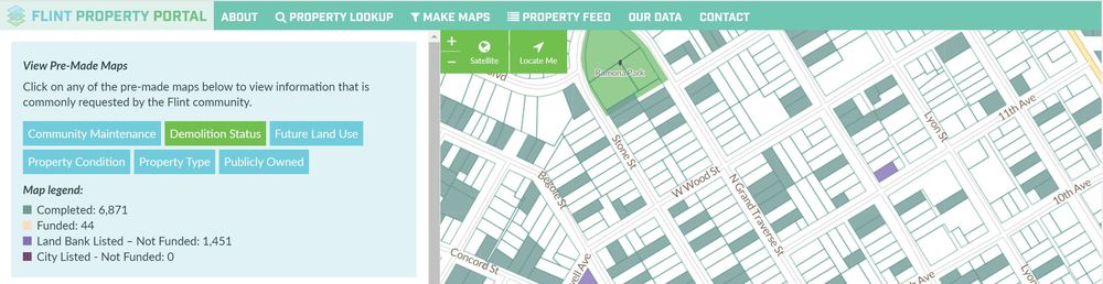
You already know that Loveland makes fantastic GIS software for visualizing and managing property information out of the box via our flagship platform, Landgrid.com. However, many of our most powerful projects have customized the look and feel of our software to the exact needs of a business, government, or community development organization (the Flint Property Portal is a great example).
In the past these projects were one-offs, meaning that the cool features that we made for one client we couldn’t easily replicate for others. What we have now for the first time is the ability to create these for pretty much any Enterprise customer who would like one, at scale.
What this means:
No matter what you’re using our platform and/or data for, we can customize a site that’ll make it all about you and your needs. We can change the look and feel of the site visually, as well as highlighting the information you need and removing anything you don’t. If you’ve ever thought “I wish I could do X thing with this data”, the time has come - now you can. I think you’ll agree, that’s pretty compelling.
So, what exactly is a white label? Glad you asked, and here’s a handy graphic to help explain.
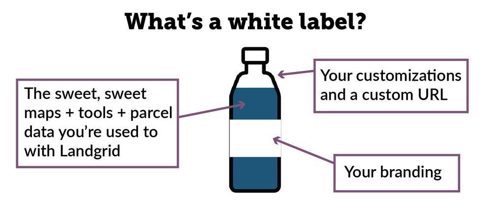
As you can probably gather, white labeling is a broad concept and can apply to a lot of potential use cases, which is one of the reasons I think it’s so cool. For existing clients, white labeling can really supercharge the impact, utility, and visibility of their work with Landgrid; in addition, I also anticipate a whole swath of potential new customers for whom we suddenly become relevant and attractive.
Rather than continuing in generalities, I thought I’d lay out some specific examples of things that white labeling now allows us to get into via some friendly hypotheticals. If any of these spark an idea for you, your business, or someone you know, please check out our revamped Enterprise page and shoot me an email at enterprise@landgrid.com. As always, we’re more than happy to talk through the details as they relate to you specifically - we're a friendly bunch and love to take customers all the way from concept to finished product.
Real Estate
Scenario 1
You’re a real estate company with a portfolio of properties which you hold and/or manage. Your investors want to be able to quickly and easily see which properties are owned, status updates as they occur, and track potential future investments.
Solution
With a white labeled site, you can give your investors access to a private site at a URL of your choosing, with your companies’ branding, that color-codes properties by ownership or as potential leads. Property managers during their daily work or staff scoping out potential acquisitions use the Landgrid app to snap photos and make notes about properties, all of which shows up in real time on a customized field.
Scenario 2
You’re a realtor whose primary interest is in a specific region (or regions) of the country. You want the latest property transfer data as well as any other metrics you can get your hands on that will help you determine which properties to take on and how to market them.
Solution
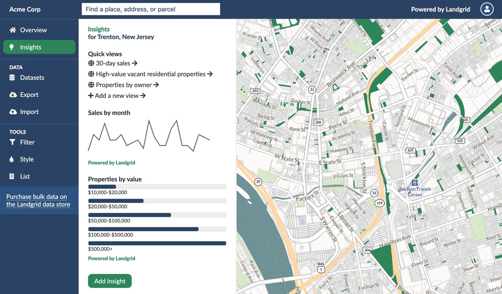
We’re bulking up our customizations so that you could set up a white label solution that pulls the metrics you’re interested in onto an Insights dashboard. You could see the number and sales value of properties sold in an area over time, bookmark properties you want to check out, and set up a data integration so that other sales data you have access to flows into your Landgrid account automatically.
Scenario 3
You’re a real estate investor, and you specialize in certain types of properties (commercial, vacant lots, residential rehab, etc). You need access to data that will give you an edge on finding these properties before your competitors.
Solution
Here, we’d set up some customizations on an Insights dashboard that could flag properties that fit your criteria as soon as they become available, in addition to some premade maps that would (for example) color code vacant commercial structures as yellow, vacant residential structures as blue, etc. Using this information, you could either go out and visit them in person with our survey app, or use it as a starting point to do outreach to the owners of those properties or other research.
Land Bank
Scenario 4
You’re a land bank, and you need a way to track properties from abandonment and vacancy, through acquisition, all the way to sale and transfer to new owners. You have hundreds of these properties, and it’s becoming a huge hassle to keep track of them all and make sure you have the most current data for any given property!
Solution
First of all, if you were using a database software to track properties, we could integrate with that - so that changes you make there get reflected onto our map. If you were doing it more, let’s say, “old school” via paper or a simple spreadsheet, we would be happy to consult, design and set up a new workflow for you that uses Landgrid primarily, making far more efficient use of you and your staff’s time going forward.
Nonprofit/Government
Scenario 5
You’re concerned with the increasing number of tax delinquent properties in your area, and you need segmented data, as well as a way of tracking outreach to residents.
Solution
We could set you up with a custom site that would have a handful of premade maps: one highlighting tax delinquent properties, one highlighting properties that have had outreach (what, when, and status), and a handful of other premade maps showing things like valuation and transfers so that you can anticipate which areas to pay special attention to in the coming months.
Scenario 6
You're a municipal government looking for a user-friendly way to publicly show the various investments and projects being undertaken by the city, because you value transparency and open data.
Solution
We’d set up for you an attractive public-facing interface as well as the training needed for staff to input data; premade maps for each area (streetscape improvements, paving projects, tree planting, etc) could be created. All data could be integrated with an existing Open Data portal if it exists for easy resident download, and/or we could host those downloads on the white labeled site itself.
Academic
Scenario 7
You’re digitizing hard-copy historic data (Census, building records, sales data, photos, etc) and you need a platform to input this data and tie it to the current parcel. You want the final product to be available to other researchers in the future.
Solution
Rather than recreate the wheel, you can use a site with Landgrid’s parcels as a georeferenced base on which to append your data. This site can be used by any number of staff while digitizing to submit records, and once the project is complete, you could work with Landgrid staff to visualize the data in whatever way feels most compelling. Project leaders could view productivity stats for staff working on the project, review digitized records, and flag any in need of further review.
Philanthropic
Scenario 8
You want a dashboard that can track investments you’ve made in a given city, or nationwide. In addition, you want to be able to easily see specific information that might inform data-driven decisions around equitable funding, and identify existing gaps in the funding you provide.
Solution
We can create an attractive interface that you can use to generate needed metrics for funders quickly ("we have funded 20 projects in ZIP code XYZ, 3 of which were arts & culture grants, and invested $3m") on a map which can be private or public.


