By Sahana Murthy
on March 16, 2021
· How-To

Dear Friends of Loveland Parcel Data and landgrid.com,
A summary of updates in February of 2021 and the upcoming pipeline is below.
Key Data Stats:
- Average parcel age - 209 days, up from 198 last month.
- Average county age - 267 days, down from 275 last month.
- Added 105,129 parcels and refreshed 161 counties since last month.
USPS Vacancy, Residential indicators: Now updated monthly. Updated in February 2021, next update in March.
Coverage Report: Updated for this month and available here:
https://docs.google.com/spreadsheets/d/1q0PZB72nO8935EMGmsh3864VjEAMUE-pdHcPkoAiS5c/
For all full dataset customers, the updated data is available for download to bulk data clients in these formats: GeoPKG .gpkg (suggested), GeoJSON, Shapefile, and Postgres SQL files. In addition, this data has been updated on the landgrid.com website.
If your organization uses a custom export we are updating your data at the moment and if you don’t see the latest updates, please drop us a line.
A Data Dictionary for the Loveland Standard Schema is always available here:
https://docs.google.com/spreadsheets/d/14RcBKyiEGa7q-SR0rFnDHVcovb9uegPJ3sfb3WlNPc0/
A machine-readable version of this list is included in the `verse` table available in all the formats above as well as CSV format for use in spreadsheets. To find the latest updates in verse, sort by 'last_refresh' and use the 'filename_stem' column to identify the file.
Data refreshed or added from the county in February and live now:
( Asterisk * indicates newly added county)
--------------------------------------------------
Hawaii - Hawaii, Honolulu, Kalawao, Kauai, Maui
Illinois - Vermilion
Kentucky - Jefferson
Nebraska - Adams, Antelope, Arthur, Banner, Blaine, Boone, Box Butte, Boyd, Brown, Buffalo, Burt, Butler, Cass, Cedar, Chase, Cherry, Cheyenne, Clay, Colfax, Cuming, Custer, Dakota, Dawes, Dawson, Deuel, Dixon, Douglas, Fillmore, Franklin, Frontier, Furnas, Gage, Garden, Garfield, Gosper, Grant, Greeley, Hall, Hamilton, Harlan, Hayes, Hitchcock, Holt, Hooker, Howard, Jefferson, Johnson, Kearney, Keith, Keya Paha, Kimball, Knox, Lancaster, Lincoln, Logan, Loup, Madison, McPherson, Merrick, Morrill, Nance, Nemaha, Nuckolls, Otoe, Pawnee, Perkins, Phelps, Pierce, Platte, Polk, Red Willow, Richardson, Rock, Saline, Sarpy, Saunders, Seward, Sheridan, Sherman, Sioux, Stanton, Thayer, Thomas, Thurston, Valley, Washington, Wayne, Webster, Wheeler, York
Oregon - Benton
Pennsylvania - Adams, Allegheny, Beaver, Bedford, Berks, Blair, Bradford, Bucks, Butler, Cambria, Carbon, Centre, Chester, Clarion, Clinton, Columbia, Crawford, Cumberland, Dauphin, Delaware, Erie, Fayette, Forest, Franklin, Fulton, Greene, Huntingdon, Juniata, Lackawanna, Lancaster, Lawrence, Lebanon, Lehigh, Luzerne, Lycoming, McKean, Mercer, Mifflin, Monroe, Montgomery, Montour, Northampton, Northumberland, Perry, Philadelphia, Pike, Potter, Schuylkill, Snyder, Somerset, Sullivan, Susquehanna, Tioga, Union, Venango, Warren, Washington, Wayne, Westmoreland, Wyoming, York
Texas - Bexar
Wisconsin - Milwaukee
In the current pipeline for updating in March 2021
--------------------------------------------------
Alaska
Idaho
Minnesota
Oklahoma
Rhode Island
Vermont
Michigan
In the pipeline for updating in April 2021
--------------------------------------------------
Alabama
Connecticut
Texas
Based on feedback and county challenges, pipeline planning is always subject to change. As always, please contact us if you have any questions about accessing or using the data, you find issues with any of our data, or you have any comments or questions about our data in specific areas or states. We also love to hear from you about which counties or regions you’d like to see us update next, as it helps inform our planning process.
Thank you for being a part of Loveland!
Happy Mapping!
Blake Girardot
blake@landgrid.com
Loveland Data Team
313-649-LAND
By Raven Visser
on February 19, 2021
· How-To

The parcel data made available by counties across the US varies widely in how land use is classified (if that information is available at all). Our standardized land use codes describe each parcel across five dimensions (Activity, Function, Structure, Site, and Ownership). These codes are 4-digit numbers, with the first digit denoting the broadest category, and each successive digit describing the parcel in more detail. For example, in the Activity dimension:
-
An Activity code of 3000 means 'Industrial, manufacturing, and waste-related activities'.
-
An Activity code of 3100 has one more digit of detail--it still falls under the above description, but it refers to 'Plant, factory, or heavy goods storage or handling activities'.
-
An Activity code of 3120 means 'Primarily goods storage or handling activities'--still industrial in nature, and related to plant, factory, or heavy goods storage or handling, but much more specific!
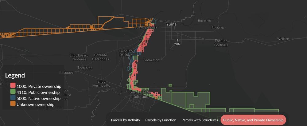
In the image below, where codes are indented to show their hierarchy, you can see how an Activity code of 3120 is just one of several different codes (e.g. 3110, 3120, 3210, 3220, 3230) at the same level of specificity (three digits):

When you expand this potential for specificity across five dimensions, each intended to describe an aspect of the land use for a particular parcel, you can see how useful Loveland's standardized land use codes can be to identify land used for general or specific purposes.
Our standardized land use codes are derived from the Land-Based Classification System (LBCS), a method devised by the American Planning Association. Activity describes the actual human activities that take place on the parcel, while Function describes the broader economic or social use the parcel serves. Structure and Site describe the type of structure on a parcel and, independently, whether the parcel is developed or not. Ownership describes whether the owner of the parcel is a public or private entity.
The five-dimension approach gives a sense of what is actually there for any given parcel, and we fill as many of the five dimensions as we can when we apply our standardized land use codes. This work is done manually, county by county, matching each place's assessor-provided land use information (where available) to the applicable codes for each dimension. For example, a parcel that is used as a parking lot for a public school would be encoded like this using our system:
-
Activity: 5210 (Vehicular parking, storage, etc.)
-
Function: 6100 (Educational services)
-
Structure: 5200 (Automobile parking facilities)
-
Site: 5300 (Developed site with roads, train tracks, and other linear structures)
-
Ownership: 6100 (Nonprofit educational)
Whereas, in a traditional single-dimension system, a choice would have to be made between classifying that same school parking lot as simply "parking" or "educational", or possibly even just "public property".
Currently, in the top 50 metro areas in the country, over 80% of parcels have codes for Activity and Function, and over 60% have codes for Structure and Site. In Loveland's entire nationwide dataset of more than 147 million parcels, two-thirds of all parcels have a standardized land use code for Activity and Function. We continually add new places and fill in codes for existing ones. You can stay up to date on which places have standardized land use codes using our coverage report.
In addition to the standardized land use codes, our data also includes human-readable '_description' fields for each dimension. To use the same example from earlier, an 'lbcs_activity' value of 3120 would have an 'lbcs_activity_description' value of 'Primarily goods storage or handling'. We keep the standardized land use codes and text descriptions separate to allow for easier processing and sorting of our data.
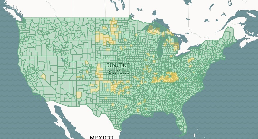
Users of Loveland's data and the mapping platform can perform queries to find patterns across the dataset, or to count certain types of parcels. Our Border Parcels project shows how our standardized land use codes can be used to generate insights into how land is used across areas of interest that span multiple states and counties, each of which provided entirely separate and incompatible land use data.
Likewise, finding and mapping all the residential parcels in a city could help with understanding and tracking the spread of disease outbreaks like the current COVID-19 pandemic. If you are a local government or a fellow mapping and data company that could use parcel data to push forward your study, outreach efforts and research on COVID-19, or if you have questions about LBCS in general, please contact us at team@landgrid.com, or check out the parcel data FAQ.
Happy Mapping!
Ray Visser
ray@landgrid.com
Loveland Data Team
313-649-LAND
By Sahana Murthy
on January 15, 2021
· How-To
Dear Friends of Loveland Parcel Data and landgrid.com,
A summary of updates in December of 2020 and the upcoming pipeline is below.
Key Data Stats:
- Average parcel age - 205 days, up from 193 last month.
- Average county age - 277 days, up from 254 last month.
- Added 41,571 parcels and refreshed 82 counties since last month.
In keeping with these stats, please take a moment to review our end of the year parcel data report from 2020 - This report shows all the key improvements we made to our data in 2020 - https://landgrid.com/reports/2020report

USPS Vacancy, Residential indicators: Now updated monthly. Updated in December 2020, next update in January.
Coverage Report: Updated for this month and available here:
https://docs.google.com/spreadsheets/d/1q0PZB72nO8935EMGmsh3864VjEAMUE-pdHcPkoAiS5c/
For all full dataset customers, the updated data is available for download to bulk data clients in these formats: GeoPKG .gpkg (suggested), GeoJSON, Shapefile, and Postgres SQL files. In addition, this data has been updated on the landgrid.com website.
If your organization uses a custom export we are updating your data at the moment and if you don’t see the latest updates, please drop us a line.
A Data Dictionary for the Loveland Standard Schema is always available here:
https://docs.google.com/spreadsheets/d/14RcBKyiEGa7q-SR0rFnDHVcovb9uegPJ3sfb3WlNPc0/
A machine-readable version of this list is included in the `verse` table available in all the formats above as well as CSV format for use in spreadsheets. To find the latest updates in verse, sort by 'last_refresh' and use the 'filename_stem' column to identify the file.
Data refreshed or added from the county in December and live now:
( Asterisk * indicates newly added county)
--------------------------------------------------
Alabama - Jefferson
California - El Dorado
Georgia - Chatham, Cobb, DeKalb, Gwinnett
Indiana - Allen, Hamilton, Lake, Madison, Marion, St. Joseph, Vanderburgh
Kentucky - Oldham
Michigan - Branch, Menominee, Oakland
Minnesota - Mower
Missouri - Adair, Cole, Jackson, Madison, St. Louis City, Ste. Genevieve, Wayne
Northern Mariana Islands - Rota, Saipan, Tinian
North Carolina - Mecklenburg, Wake
Ohio - Pickaway
Oregon - Multnomah
Pennsylvania - Philadelphia
South Carolina - Abbeville, Aiken, Allendale, Anderson, Bamberg, Beaufort, Berkeley, Calhoun, Charleston, Cherokee, Chester, Chesterfield, Colleton, Darlington, Dillon, Dorchester, Edgefield, Fairfield, Florence, Georgetown, Greenville, Greenwood, Hampton, Horry, Jasper, Kershaw, Lancaster, Laurens, Lee, Lexington, Marion, Marlboro, McCormick, Newberry, Oconee, Orangeburg, Pickens, Richland, Saluda, Spartanburg, Sumter, Union, Williamsburg, York
Tennessee - Shelby
Texas - Tarrant
Virginia - Mecklenburg, Rockingham
Wisconsin - Milwaukee
In the current pipeline for updating in January 2021
--------------------------------------------------
West Virginia
Wyoming
Washington
North Carolina
Oregon
In the pipeline for updating in February 2021
--------------------------------------------------
Alaska
Hawaii
Indiana
Pennsylvania
Based on feedback and county challenges, pipeline planning is always subject to change. As always, please contact us if you have any questions about accessing or using the data, you find issues with any of our data, or you have any comments or questions about our data in specific areas or states. We also love to hear from you about which counties or regions you’d like to see us update next, as it helps inform our planning process.
Thank you for being a part of Loveland!
Happy Mapping!
Blake Girardot
blake@landgrid.com
Loveland Data Team
313-649-LAND
By Sahana Murthy
on November 5, 2020
· How-To
Dear Friends of Loveland Parcel Data and landgrid.com,
A summary of updates in October of 2020 and the upcoming pipeline is below.
Key Data Stats:
- Average parcel age - 207 days, the same as last month.
- Average county age - 248 days, down from 249 last month.
- ~ 214K parcels added & 225 counties refreshed.
Loveland Parcel Schema - Upcoming changes
Please review the Data Dictionary below for the proposed attribute columns to add. Cropland Data Layer attributes will be added to the schema for next month's export. We are also adding in an additional mailing address related field, 'mail_country'. This month, the schema is the same as is has been, all the schema changes start with next month's exports.
USPS Vacancy, Residential indicators: Now updated monthly. Updated in October 2020, next update in November.
Coverage Report: Updated for this month and available here:
https://docs.google.com/spreadsheets/d/1q0PZB72nO8935EMGmsh3864VjEAMUE-pdHcPkoAiS5c/
For all full dataset customers, the updated data is available for download to bulk data clients in these formats: GeoPKG .gpkg (suggested), GeoJSON, Shapefile, and Postgres SQL files. In addition, this data has been updated on the landgrid.com website.
If your organization uses a custom export we are updating your data at the moment and if you don’t see the latest updates, please drop us a line.
A Data Dictionary for the Loveland Standard Schema is always available here:
https://docs.google.com/spreadsheets/d/14RcBKyiEGa7q-SR0rFnDHVcovb9uegPJ3sfb3WlNPc0/
A machine-readable version of this list is included in the `verse` table available in all the formats above as well as CSV format for use in spreadsheets. To find the latest updates in verse, sort by 'last_refresh' and use the 'filename_stem' column to identify the file.
Data refreshed or added from the county in September and live now:
( Asterisk * indicates newly added county)
--------------------------------------------------
Delaware - Kent, New Castle, Sussex
Illinois - Adams, Bond, Boone, Bureau, Calhoun, Champaign, Christian, Clark, Clay, Clinton, Coles, Crawford, Cumberland, De Witt, Douglas, DuPage, Edgar, Effingham, Fayette, Ford, Franklin, Fulton, Gallatin, Grundy, Hamilton, Hancock, Henderson, Henry, Iroquois, Jackson, Jasper, Jefferson, Jersey, Kane, Kankakee, Kendall, Knox, Lake, Lawrence, Lee, Logan, Macon, Marion, Marshall, Mason, Massac, McDonough, McHenry, McLean, Menard, Monroe, Morgan, Moultrie, Peoria, Perry, Piatt, Pike, Randolph, Richland, Rock Island, Sangamon, Schuyler, Shelby, St. Clair, Stark, Stephenson, Tazewell, Vermilion, Warren, Washington, White, Whiteside, Will, Williamson, Winnebago, Woodford
Michigan - Missaukee
New York - Erie
Ohio - Lucas
Pennsylvania - Delaware, Lehigh
Tennessee - Blount, Bradley, Carter, Cheatham, Davidson, Hamilton, Jefferson, Knox, Lincoln, Maury, Montgomery, Robertson, Sevier, Sullivan, Tipton, Unicoi, Warren, Washington
Texas - Milam
Virginia - Accomack, Albemarle, Alexandria, Alleghany, Amelia, Amherst, Appomattox, Arlington, Augusta, Bath, Bedford, Bland, Botetourt, Bristol, Buchanan, Campbell, Caroline, Carroll, Charles City, Charlotte, Charlottesville, Chesapeake, Chesterfield, Clarke, Colonial Heights, Covington, Culpeper, Danville, Dinwiddie, Emporia, Essex, Fairfax City, Falls Church, Fauquier, Floyd, Fluvanna, Franklin, Franklin City, Frederick, Fredericksburg, Galax, Giles, Gloucester, Goochland, Grayson, Greene, Greensville, Halifax, Hampton, Hanover, Harrisonburg, Henrico, Henry, Highland, Hopewell, Isle of Wight, James City, King George, King William, King and Queen, Lancaster, Lee, Lexington, Loudoun, Louisa, Lunenburg, Lynchburg, Madison, Manassas, Manassas Park, Martinsville, Mathews, Mecklenburg, Middlesex, Montgomery, Nelson, New Kent, Newport News, Norfolk, Northampton, Northumberland, Norton, Nottoway, Orange, Page, Patrick, Pittsylvania, Poquoson, Portsmouth, Powhatan, Prince Edward, Prince George, Prince William, Pulaski, Radford, Richmond, Richmond City, Roanoke, Roanoke City, Rockbridge, Russell, Salem, Scott, Shenandoah, Smyth, Southampton, Spotsylvania, Stafford, Staunton, Suffolk, Surry, Sussex, Tazewell, Virginia Beach, Warren, Washington, Waynesboro, Westmoreland, Williamsburg, Winchester, Wise, Wythe, York
Wisconsin - Milwaukee
In the current pipeline for updating in November 2020
--------------------------------------------------
Colorado
Florida
Ohio
In the pipeline for updating in December 2020
--------------------------------------------------
South Carolina
Based on feedback and county challenges, pipeline planning is always subject to change. As always, please contact us if you have any questions about accessing or using the data, you find issues with any of our data, or you have any comments or questions about our data in specific areas or states. We also love to hear from you about which counties or regions you’d like to see us update next, as it helps inform our planning process.
Thank you for being a part of Loveland!
Happy Mapping!


