Survey Property at Light Speed: Site Control + Street View
By Alex Alsup on May 6, 2016
Evaluating Property with Site Control + Google Street View
Are you a real estate appraiser who needs to collect parcel-level data on properties and neighborhoods quickly? A city on a tight budget, trying to evaluate housing stock? A researcher collecting data on properties to inform your studies and analysis? If so, we've got a pretty awesome tool for you...
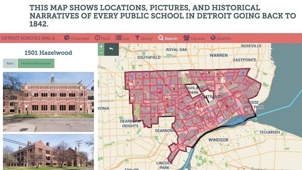
Watch the video below to see how you can use LOVELAND's Site Control to create custom property surveys, evaluate properties via Google Street View, and attach data to the assessment records of any of the more than 115 million parcels LOVELAND has online across the United States.
Now in Site Control: The Street View Surveyor
With Site Control and the Street View Surveyor, you can collect parcel level data on thousands of properties in record time.
But, it's not just Street View imagery at your property surveying fingertips: We can consume imagery via API from other third party street level and oblique / orthogonal imagery providers. If you're working with third-party providers of high resolution imagery, LOVELAND can feed your provider's imagery into Site Control, allowing you to code high resolution imagery in record time.
The LOVELAND Surveyor Interface in Action

When to Use Street View vs. In-Person Surveying
If you’re thinking, “But Street View is often years old. How can I trust its imagery when I know things change? I don't think it can replace a person who's familiar with the city out surveying in person.”
Trust us, we hear you. Nothing can replace a human in the street evaluating a property, talking to neighbors, and taking up-to-the-moment photography, but that can be an expensive proposition. Surveying via Street View can help you evaluate many properties quickly, and identify the ones that you think need in-person follow up.
When you decide it's time for a surveyor on the ground, they can hit the field with the LOVELAND App and survey using the exact same questions used in your Street View evaluation. This can augment your Street View surveying, giving you an up-to-the-moment understanding of conditions, and collecting insight from neighbors or occupants to gather deeper information on the property.
We want to help you focus your survey personnel on the properties and areas where you know conditions are more dynamic, and the human eye is far mightier than Street View’s.

Freshness of Street View Imagery
Street View’s drive-thru regularity varies widely, typically based on a city’s size. However, there are many places where LOVELAND has parcel coverage, and Street View drives regularly.
To help those of you who are interested in this tool and wondering how recent the Street View imagery is in your city, we’ve assembled a list of just a few of the major counties & cities where LOVELAND has parcel shapes and data, and Street View imagery is less than a year old.
Some major cities with Street View imagery less than a year old:
- Dallas, Texas
- Chicago, Illinois
- Jacksonville, Florida
- Tampa, Florida
- Miami, Florida
- Houston, Texas
- Austin, Texas
- Louisville, Kentucky
- Columbus, Ohio
- Pittsburgh, Pennsylvania
- Milwaukee, Wisconsin
- San Diego, California
- Los Angeles, California
- San Francisco, California
- Oakland, California
- Portland, Oregon
- Seattle, Washington
- Las Vegas, Nevada
- Salt Lake City, Utah
If you're curious when Street View imagery was last collected in your city or town, just go to Street View in your area and look in the lower right hand corner of the screen, as you see below:

Sample Results of a Street View Survey
In the map below, you can explore the results of a very simple one-question property survey conducted over 250 or so parcels on Chicago's South Side.
The job was to answer one question: Is the property vacant? Street View imagery in Chicago is very recent -- circa November 2015 -- so a quick scan of the area can reveal where vacancies are likely, and further follow ups with those properties can happen through in-person surveys of just those parcels, limiting the amount of on-the-ground time and expense.
Thank you, Google
Finally, a word for Google, if you’re out there, thank you for Street View. Its value is tremendous and we believe only beginning to be realized. We hope that we’re playing some small part in demonstrating what it can do. And I couldn’t end this without asking -- Please, pretty please, may we have API access to Street View Time Machine imagery?
That’s when the real fireworks start (#changeovertime).
Thank you from Team LOVELAND.