By Sahana Murthy
on August 19, 2019
· Announcements
Announcement:
We changed the name of our Loveland Next App to the "Landgrid App" to keep our product suite branding consistent.
The app is exactly the same with some functaionality improvements and a better name.
Stay tuned with our app updates because we are adding a ton of new features and functionality to it in the coming weeks!
That's Loveland for you! Constantly improving !
- Team Loveland
By Sahana Murthy
on August 6, 2019
· Announcements

Loveland Technologies CEO, Jerry Paffendorf, here.
2019 marks the 10-year anniversary of Loveland Technologies. We’ve evolved a great deal over time, but it’s all been one journey to bring the landgrid to you in different forms. I’m very happy to say that the team and the business are better than they’ve ever been, and we’re excited for our future.
This weekend I’m getting married to one of my co-founders. No, it’s not Larry, though there would be nothing wrong with that. He’s great. Fantastic even. But it’s Mary and I who have chosen to…marry. And Larry will be there.
Those of you who know us know this isn’t a sudden thing. She and I have basically been together since we started working together. Our relationship is one of the many things that keeps our company strong.

Last year she and I started splitting our time between Detroit and the Keweenaw Peninsula of Michigan’s Upper Peninsula, surrounded by Lake Superior. This is about as far away from Detroit as you can get while still being in the Mitten State, and about as far away from Detroit as New York City.

We have a place in the historic copper mining community of Calumet, which for a time in the 1800s was the wealthiest and most populous area in Michigan. I’m loving learning about the geology and the history of the Copper Country in all its forms: immigration, labor, economy, weather, rocks, buildings, land use, wilderness, Lake Superior, pre-industrial indigenous copper trade, all of it.
Just as some natural resource or another led to the creation of all cities, it was the uniquely pure copper in the ground that originally brought investment capital from Boston and other cities to this place, and immigrants from across Europe to work dangerous jobs in the mines — which go down 6,000 feet in places — and to brave winters that can produce 30 feet of snow. Originally all of the land was owned by the mining companies who rented homes to their workers and built public amenities for them — some of which are truly marvelous — in a complicated relationship sometimes called “benevolent paternalism” that was more common closer to the founding of the country.
Today the mines are long closed, but the history remains visible to the naked eye, and gets richer the more you read and learn and study maps. In the vacuum left by the mining companies, the federal and state governments have stepped in to help preserve assets in the area — Calumet and parts of the Keweenaw are in a National Park. Conservationists have been acquiring land to preserve the natural beauty of the place and build trail systems, and people are chipping away at reviving the vacant historic buildings downtown.
One of the things that’s kept me happily occupied with our work for a decade is that the scope of applications for the landgrid and things to learn about the landgrid are endless. It covers everything, and how the land is subdivided, owned, taxed, and used is so fundamental to what makes places sick or healthy, beautiful or janky, attractive or overlooked. We can literally work anywhere and find something meaningful and important to do that can improve life, government, business, and land use in that place.
Over time I’ve come to understand that, while it isn’t the only thing, if you can’t know the landgrid then you can’t know a place, you can’t manage a place, and you’ll have a very hard time making good decisions for the future. You might even lose a place if you’re not paying attention to what’s happening on the landgrid. The story plays out differently in big cities and rural places, but it’s all theme and variation.
I share all this because I know that you care about the parts of the landgrid that apply to your life and work and interests and community, and I want to make it abundantly clear that we care, too.
We work very hard to provide you with tools and data to make understanding and working with the landgrid easier. Doing this feels less like a job and more like a calling to build something fundamental that feels like it’s missing from the world.
Over the years we’ve been able to be a part of so many projects with so many great partners, and we look forward to doing it for years to come while getting better all the time. As we continue, I ask that you please keep us as your trusted partners for all things parcel data, and if we haven’t worked together yet, please don’t be shy about letting us know how we can help. No matter what part of the country you’re in, if you need to understand the landgrid and life on the landgrid locally or nationally, we’re here for you with tools, data, experience, lessons from the past, and an eye for the future.
Look out for some big announcements from our team later this year, thank you for being a part of the journey so far, and contact us any time at team@landgrid.com.
Now if you’ll excuse me, I have to go work on a seating chart — basically just another landgrid in table form,
Jerry Paffendorf
CEO, Loveland Technologies
By Sahana Murthy
on August 1, 2019
· Announcements
The Loveland team is back to checkin with our amazing & loyal family of friends, customers & partners.
So what happened this July - Heat waves everywhere, including a record high temperature of 101 degree F in London. Unheard of!!!
While the world has been sizzling, the Loveland team has been trying to find ways to empower people & communities all over.
Working with local governments, land banks & communities to help fight very real issues -blight & tax foreclosure, property data challenges, land survey challenges etc has been keeping us busy & fulfilled.
Here’s what we have for you in the August edition:
1. Landgrid Enterprise for Municipalities:
Here’s a call out to our friends in local municipalities around the country. Landgrid Enterprise is built to help solve your property data & inventory challenges.
Solving real problems across communities is what we do best. We recently spoke to a few communities and found that there is a lot of value in the Landgrid Enterprise platform for MUNICIPALITIES.
How can we help you, you ask???
Most municipal government employees find themselves with lots of work to do, but limited hours in the day. That’s the core problem that Landgrid sets out to help you solve - using our maps and data tools, you and your staff can work more efficiently, use data to make better decisions, and look good as your productivity improves!
Services we offer:
- Consulting to streamline your existing workflow and save you time
- Data cleaning and importing
- Survey app to easily collect data and document results when out in the field
- Powerful mapping tools to help you see and understand your data
- Easy importing and exporting means your data’s never ‘stuck’
- Expertise regarding tax delinquency and blight strategies
Does any of this resonate with you???
Similarly…..
2. Landgrid Enterprise for Historic Districts:
Our quest for helping local governments recently had us stumbling upon the incredible historic district communities across the country and their need for an updated inventory of properties to retain their historic status.
Did you know that every State has a Historic Preservation Office as a result of the National Historic Preservation Act of 1966???
Many States have local historic districts that are tasked with documenting, enforcing, advising, and providing outreach when it comes to historic preservation of both individual structures and entire historic neighborhoods. In the state of Michigan, there is a requirement of “Maintaining a system for the survey and inventory of historic resources”.
Landgrid can help here. With our built in survey editor, our survey expertise & our easy to use Loveland survey phone app, local governments in all historic districts can easily inventory property data in a matter of a week. All you need is to be set up with our platform and may be some happy volunteers from your town.
Surveying expertise runs through the Landgrid team. It’s time to tap into it!
If you or anyone you love is a municipality or a historic district, just holler at enterprise@landgrid.com and we will have you set up in no time.
3. Landgrid Webcasts - Fighting Blight with Jerry Paffendorf!
This July, we kickstarted our educational & awareness series of webcasts meant to bring awareness to core problems that we work on and to also provide helpful, tutorial content for our users.
This week, we launched these webcasts with an amazing discussion on Blight in Detroit with none other than our CEO - Jerry Paffendorf, who has been at the forefront of this fight in Detroit for close to a decade now. In case you missed it, here's also a link to the video - https://landgrid.com/pages/tutorial-videos#w1
This video is a 101 Primer on all things Blight!
The sheer depth of knowledge goes to show how much time Loveland founders have invested in trying to help with this core issue here in Detroit.
Solving real problems across communities in America is at the core of Loveland's value & mission and we are so proud of how far we have come from our humble beginnings!
Stay tuned with our social media posts and content (social media links are embedded in the footer of this email). There will be many more of these helpful webinars & webcasts coming from our team.
And ...Finally……
4. Customer Spotlight - Michigan Humane Society
If you have been following our newsletters these past few months, you know that we always end our email updates with a spotlight on our customer.
We love our customers and want to celebrate them. We recently worked with the Michigan Humane Society, who do such good work on a daily basis, selflessly with a smile on their face.
Meet, Becki Kenderes who recently used the Loveland Next App for their outreach program to ensure animals are kept in their homes and well taken for and not relegated to shelters.
This is what Becki had to say about her experience with Loveland:
"To keep animals in their homes and out of shelters, the Michigan Humane Society recently launched an outreach program in the neighborhoods surrounding our Detroit shelter. Through this program, we provide free food, supplies and other resources to pet owners in need. We’ve created a custom survey using the Loveland Next app that helps us effortlessly track critical information like which homes we’ve attempted to visit, where pets live and which areas we don’t need to revisit (such as vacant lots and vacant properties)."

Becki, you give us too much credit. You & your team are the real heroes here. And of course, let's not forget the animals (true heroes, who make our lives better & happier).
That wraps up updates from July for this edition.
We will see you back in a month’s time with hopefully even better, more exciting updates.
That’s the goal. To keep getting better with time - like fine wine!
Sahana Murthy
General Manager
sahana@landgrid.com
By Sahana Murthy
on July 16, 2019
· How-To
This year Loveland has seen many changes and milestones. All of which we are so proud of.
We changed our site from makeloveland.com & platform from sitecontrol.us to Landgrid.com. Our suite of products now sit under the umbrella of the Landgrid mapping platform & Landgrid data. We launched our nationwide parcel dataset this year. We are constantly working on refreshing our data and will soon be close to an average parcel age of under a year!
But through all this, the one thing that hasn’t changed is the core essence of our mapping platform that literally provides the American land grid in a beautiful, GIS interface to everyone.
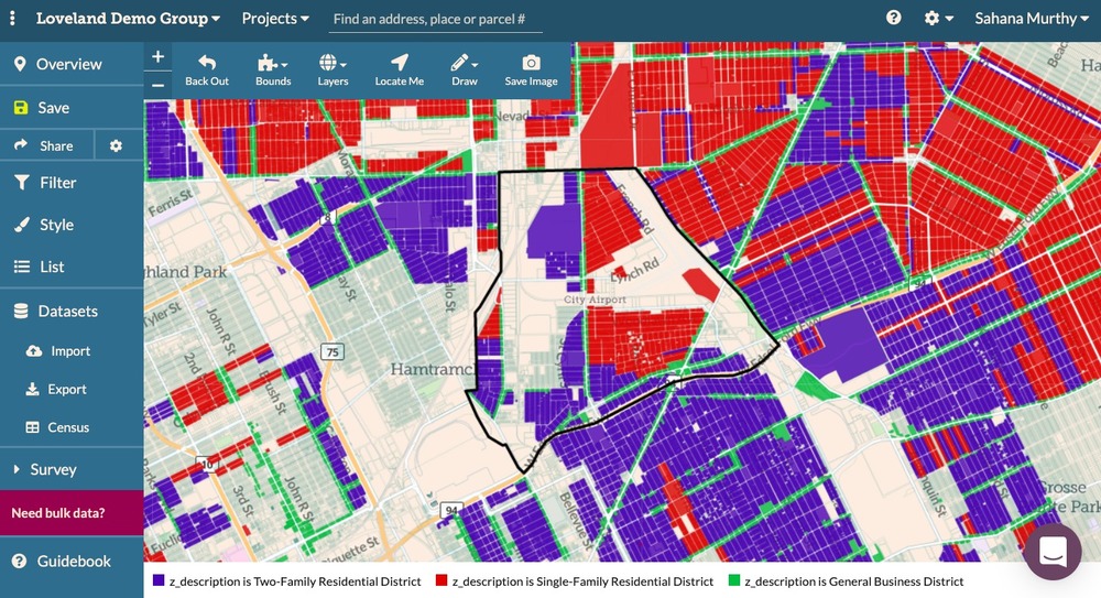
Of course, the interface has changed & gotten better over the years but our roots have remained the same. Helping individuals all over the country in discovering parcel level information in their region in an easy to use, spatial map interface! At the core of it is the Landgrid Pro solution that allows people like you and me to make maps, color code them, filter them, conduct land surveys and generally look up parcels anywhere in the country.
For someone like me who's looking to buy a home soon, this is the ideal tool. Within minutes I can look up properties that I would like to pursue, gauge what a neighborhood is like, who the top owners are in my county and find relevant census information for my location.
You can experience this tool too by simply signing up for Landgrid Pro or Landgrid Free.
Our free version will give you a taste of what we offer. But the Pro provides you with limitless functionality & features all for $10/month or discounted at $100/year.
Soon, you will be on your way to making beautiful color coded maps & surveys.
Here’s a quick snapshot of all you get with Pro:
- Unlimited Maps - Create as many beautiful maps and import as much data as you want.
- Import and export- Import & geocode your own data to parcels. Once you are done with your map, export your data as a CSV or shapefile or KML.
- Bookmarking - Bookmark properties that you find interesting by clicking the “+” button next to the address.
- Focus Area - Create a custom boundary on your map by drawing a focus area.
- Style & share - Style your data to create beautiful parcel maps, then embed or share your map with others.
- Measuring tool - Use our slick measuring tool to measure distances, areas and acreage. No more guessing!
- Multiple Layers - Add multiple layers like FEMA flood hazard or land cover to your map in addition to your base layers.
- Census Data - Quickly look up and get insight into relevant census data in your location. Can’t get easier than that!
- Unlimited Surveys - Create an unlimited number of land surveys using our survey editor. The editor comes pre built with questions if you want them but you can also generate your own survey questions to meet your project needs.
Phew… We are not yet done! There is more to Pro like the ability to filter your data to get deeper insights.
Still not sure -- Check out our tutorial videos on our Youtube channel. They will help you understand every facet of the Pro featureset. You can see how easy, simple & user friendly this tool really is.
No GIS experience required. I should know - I have no GIS experience too but I was able to make a map in just a few minutes after getting set up. Try for yourself & let me know what you think at sahana@landgrid.com.
Sign up today and be on your way to making insightful, color coded parcel maps & surveys - https://landgrid.com/plans
- Sahana Murthy
GM, Loveland Technologies
"Your go-to source for all things parcel data!"


