The Loveland Blog

Page 13

March 2020 - Landgrid Data Update

By Sahana Murthy on March 12, 2020 · Democratizing Data

Dear Friends of Loveland Parcel Data and landgrid.com,

A summary of updates in February of 2020 and the upcoming pipeline is below. 

March 2020 - Key Data Stats 

Total parcel age
 - improved by 9.3% from last month
Current average parcel age  - 257,    down from 285 last month 
Current average county age - 350,  down from 381 last month

The Landgrid Data Store - We launched the data store last week, to allow our customers to quickly buy county data on the go. Most of you have our nationwide & statewide data with updates. However, if some of you are interested in individual county data or a handful of counties, you can now just go straight to the data store and buy data by the county, hasslefree and without delays. 
https://landgrid.com/store

SPECIAL NOTE - USPS Vacancy, Residential indicators: Updated in January 2020.
We now include the CASS Error codes and additional CASS address notes for non validated addresses, as well as validated addresses. We also fixed a small bug in that process that was putting a single space place holder in the RDI and the Vacancy flag fields for non validated addresses. This has been replaced by a true NULL value now. The full dataset was re-exported to reflect those changes.

GeoDB File Format Deprecated: We still encourage you to out the GeoPackage or GeoPKG, (.gpkg) format if you can.

Coverage Report: Updated for this month and available here:
https://docs.google.com/spreadsheets/d/1q0PZB72nO8935EMGmsh3864VjEAMUE-pdHcPkoAiS5c/

For all full dataset customers, the updated data is available for download to bulk data clients in these formats: GeoPKG .gpkg (suggested), GeoJSON, Shapefile, and Postgres SQL files.  In addition, this data has been updated on the landrid.com website.

If your organization uses a custom export we are updating your data at the moment and if you don’t see the latest updates, please drop us a line.

A Data Dictionary for the Loveland Standard Schema is always available here:
https://docs.google.com/spreadsheets/d/14RcBKyiEGa7q-SR0rFnDHVcovb9uegPJ3sfb3WlNPc0/

A machine-readable version of this list is included in the `verse` table available in all the formats above as well as CSV format for use in spreadsheets. To find the latest updates in verse, sort by 'last_refresh' and use the 'filename_stem' column to identify the file.

Data updated or added from the county in February and live now:
--------------------------------------------------
Colorado (1 new) - Cheyenne

Georgia (12 new counties) - Bacon, Bartow, Bibb, Brooks, Bulloch, Camden, Charlton, Crawford, Dawson, Fannin, Glynn, Gordon, Haralson, Houston, Jeff Davis, Jones, Murray, Muscogee, Pierce, Polk, Putnam, Rockdale, Screven, Telfair, Troup, Washington, Wilcox, Wilkes

Idaho (3 new counties) - Ada, Adams, Bannock, Bear Lake, Benewah, Bingham, Blaine, Boise, Bonner, Bonneville, Boundary, Butte, Camas, Canyon, Caribou, Cassia, Clark, Clearwater, Custer, Elmore, Franklin, Fremont, Gem, Gooding, Idaho, Jefferson, Jerome, Kootenai, Latah, Lemhi, Lewis, Lincoln, Madison, Minidoka, Nez Perce, Oneida, Owyhee, Payette, Shoshone, Teton, Twin Falls, Valley, Washington

Illinois (counties refreshed) - Cook, Jersey, Piatt

Michigan (2 new counties) - Dickinson, Manistee

Missouri (17 new counties) - Andrew, Audrain, Barry, Benton, Bollinger, Boone, Buchanan, Butler, Callaway, Camden, Cape Girardeau, Carter, Christian, Clark, Clinton, Cooper, Crawford, Daviess, DeKalb, Dunklin, Gentry, Greene, Harrison, Hickory, Holt, Howard, Jasper, Jefferson, Johnson, Lewis, Maries, McDonald, Mercer, Miller, Moniteau, Monroe, Morgan, New Madrid, Newton, Nodaway, Oregon, Ozark, Pemiscot, Perry, Randolph, Reynolds, Schuyler, Scotland, Scott, Shannon, Shelby, St. Clair, St. Francois, Sullivan, Taney, Texas, Vernon, Washington, Wayne, Wright

Nebraska (5 new counties) - Adams, Blaine, Boyd, Brown, Burt, Butler, Cass, Chase, Cherry, Cheyenne, Colfax, Custer, Dakota, Douglas, Dundy, Furnas, Gage, Garfield, Grant, Hall, Harlan, Hooker, Howard, Jefferson, Keya Paha, Knox, Lancaster, Lincoln, Logan, Loup, Madison, McPherson, Otoe, Perkins, Red Willow, Richardson, Rock, Saline, Sarpy, Sherman, Valley, Washington, Wayne, Webster, Wheeler

Oklahoma (new) - Caddo

Pennsylvania (new) - Fayette

Utah (1 new county) - Beaver, Box Elder, Cache, Carbon, Daggett, Davis, Duchesne, Emery, Garfield, Grand, Iron, Juab, Kane, Millard, Morgan, Piute, Rich, Salt Lake, San Juan, Sanpete, Sevier, Summit, Tooele, Uintah, Utah, Wasatch, Washington, Wayne, Weber

Tennessee (counties refreshed) - Shelby

Washington (2 new counties) - Adams, Asotin, Benton, Chelan, Clallam, Clark, Columbia, Cowlitz, Douglas, Ferry, Franklin, Garfield, Grant, Grays Harbor, Island, Jefferson, King, Kitsap, Kittitas, Klickitat, Lewis, Lincoln, Mason, Okanogan, Pacific, Pend Oreille, Pierce, San Juan, Skagit, Skamania, Snohomish, Spokane, Stevens, Thurston, Wahkiakum, Walla Walla, Whatcom, Whitman, Yakima

Wisconsin (county refreshed) - Milwaukee

In the current pipeline for updating in March 2020
--------------------------------------------------
Hawaii - Statewide
Michigan - Wayne
Mississippi - Statewide
Pennsylvania - Statewide
Rhode Island - Statewide
New Mexico - Statewide

In the pipeline for updating in April
--------------------------------------------------
Maryland - Statewide

Based on feedback and county challenges, pipeline planning is always subject to change. As always, please contact us if you have any questions about accessing or using the data, if you find issues with any of our data, or you have any comments or questions about our data in specific areas or states. We also love to hear from you about which counties or regions you’d like to see us update next, as it helps inform our planning process.

Thank you for being a part of Loveland!

Happy Mapping!


Blake Girardot

blake@landgrid.com

Loveland Data Team

313-649-LAND


The Landgrid Data Store: Simplicity as a Service

By Sahana Murthy on March 11, 2020 · Announcements

It's not complicated: Everyone likes simplicity.

Hi everyone. Jerry from Landgrid here.

Last Thursday we rolled out the new Landgrid Data Store where you can download clean, standardized parcel data and property information for any county in the country, simply and at a great price.

Fields include addresses, ownership, land use, assessment info, property boundaries and lot sizes... even vacancy and building data. 

The store makes it easy to see exactly which fields are available for each county, when the data was last refreshed, and you can download a free sample before buying, so you’ll know exactly what you're getting. No mysteries here. And you get your file immediately.

We created the store because sometimes you just need to grab data for one or a few places that you can open and work with in your preferred software, whether that’s a spreadsheet program or a mapping tool.

I’m happy to say that on the very first day our very first customer sent us this testimonial:

"The convenience of being able to purchase data instantly from the Landgrid Parcel Data Store is unbeatable. The website was easy to use, and I was able to immediately download the data after submitting my payment. While everyone at Landgrid has always been very responsive to emails during purchase inquiries, this takes the convenience and speed of acquiring data to a new level."

- Bethany Berry, Landgrid Data Store Customer


Sometimes a breakthrough is just a change that makes things simpler. I think the new Landgrid Data Store is that kind of a breakthrough.

It perfectly compliments our parcel viewer, software, and state and nationwide data licenses to serve you parcel data however you need it, whenever you need it.

If you want to learn more about the store, how it works, and get instant answers to your questions, you can join me and my colleague Sahana for a short, 15-minute live demo webinar of the store at 3 PM ET today. Register here to save your spot: https://www.crowdcast.io/e/the-landgrid-parcel-data

Or just head to landgrid.com/store to check it out now.

All the best from the whole team!


Jerry Paffendorf
908-343-1981

CEO, LOVELAND Technologies
Landgrid.com

407 E Fort St, Suite 100
Detroit, MI 48226

Welcome to the Landgrid Parcel Data Store

By Sahana Murthy on March 4, 2020 · Announcements


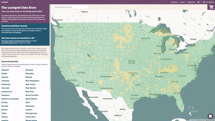
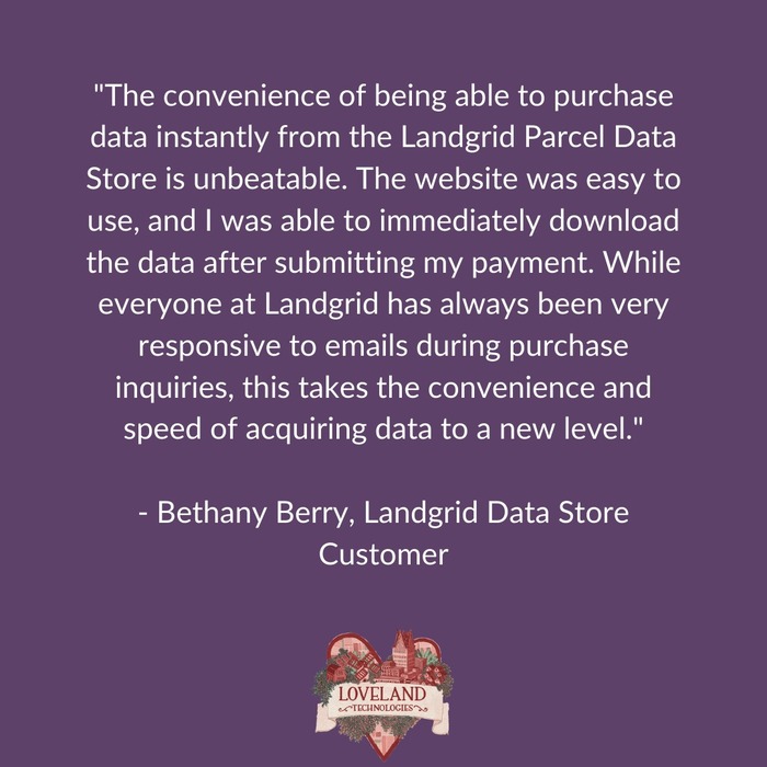
Welcome to the Landgrid Data Store – Your One-Stop Shop for all things parcel data! 

Ever need to download data from Landgrid to use in another program?

You can now visit landgrid.com/store to purchase parcel data for any individual county in the country, either as a spreadsheet or as the full shapefile with parcel geometry, with the option to add premium fields including vacancy and building counts.

The process is very straightforward. You will see exactly which fields are available for a county and when it was last refreshed, you can download a data sample for that county, and all you have to do is pay by credit card to immediately download the data in your preferred format.

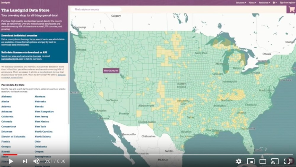
Here's a 30 second video tutorial on navigating & purchasing counties on the Landgrid data store -


With this launch, we have made it even easier for you to license our comprehensive parcel data from us - without any hassles or delays.

Here is the pricing:
CSV Data:

  • $100 for a spreadsheet of all Standard property information in any county
  • $200 for a county spreadsheet of all Premium property information, including vacancy and building counts

Shapefiles:

  • $200 for a shapefile of all Standard property information and parcel geometry in any county
  • $400 for a county shapefile of all Premium property information and parcel geometry, including vacancy and building counts

To take all of the mystery out of it, here’s exactly how the Landgrid Data Store experience works:

  1. Open the data storelandgrid.com/store. Here you will find our coverage map on the right. Green indicates places that we have data for and yellow indicates places that we are working on adding data for this year. You can also find our data dictionary of our standard schema and our coverage report for your review on the overview page. We encourage you to clearly assess the schema and the coverage report to ensure you know exactly what you would get from our data.
  2. On the overview tab, at the bottom you will find all the states listed. Based on the data you are looking for, you can select the state either here or from the coverage map.
  3. Once you select a state, you will find a list of all the counties in the state. When you are on the county page, make sure to download a “Sample” of the data for that county. We want to give you everything you need to make an informed decision before purchasing the data. 
  4. Once you are convinced that you are getting what you need, select the counties & the data format you want and simply “Add to Cart”.  Add a credit card and complete the transaction. Don’t worry. Our transactions are PCI compliant and your payment information remains secure. 
  5. You will instantly receive a confirmation email with your order details and a link to download your files. Follow the link and voila, your parcel data files at your door step in no time at all. Please note that this link stays active for a month, so be sure to download your files before the link expires.

Eezy Peezy! All this without any hassles or delays. 
A truly self-serve & seamless experience.  

We believe in transparency and making this process super easy for you. So at every step of the way you will have enough information so you know exactly what you are getting from us.

While the data store is amazing for downloading county data, if you are looking for the entire state or nationwide data access with timely data updates, then please write to us at parcels@landgrid.com and we will get you set up with it in no time.

Our bulk data prices are listed on our parcels page. We offer API access as well.

This was our March update. The team has worked so hard on this store and we are so happy & proud to be able to provide our standardized parcel data to more folks at a low price in a smooth interface. 

We will another update email coming to you soon about our nationwide land use code standardization and much more. Stay tuned with us!

Enjoy the data store and please give us your feedback on how we can improve your experience with it - team@landgrid.com

Happy Mapping!


Parcel Data Update - Feb 2020

By Sahana Murthy on February 15, 2020 · Democratizing Data

Dear Friends of Loveland Parcel Data and landgrid.com,

A summary of updates in January of 2020 and the upcoming pipeline is below:

Parcel Age Stats:

  1. Total Age:  Reduced by 8.6% in age from last month, improved by 58% from this time last year
  2. Average Parcel Age: 285,  reduced by 15.4% from 337 last month, improved by 60% from this time last year
  3. Average County Age: 381, reduced by 13.6% from 441 last month, improved by 55% from this time last year

USPS Vacancy, Residential indicators, and Situs address normalization - Updated in January 2020, and we have exported the full dataset to reflect those updates.

GeoDB File Format Deprecated - We plan to offer GeoDB files for the foreseeable future. However, we encourage people to test and switch to the GeoPackage (.gpkg.zip) files as they offer all the advantages of GeoDB, but in a better supported format. See below. We are planning on retiring the GeoDB format eventually.

GeoPackage Format - GeoPackage or GeoPKG, (.gpkg) files support geospatial data very well, with none of the limitations of shapefiles, and are faster to work with than geojsons. They are well supported by Esri tools and open source tools alike. They offer all the advantages of GeoDB files, but are better supported across the GIS tool landscape. As we sunset the GeoDB format this will be the format we suggest folks use unless a specific use case suggests another format would be better for them. (ND)GeoJSON, sql, csv, and shapefile formats will all continue to be options.

Coverage Report - Updated for this month and available here:
https://docs.google.com/spreadsheets/d/1q0PZB72nO8935EMGmsh3864VjEAMUE-pdHcPkoAiS5c/

For all full dataset customers, the updated data is available for download to bulk data clients in these formats: GeoPKG .gpkg (suggested), GeoJSON, Shapefile, and Postgres SQL files.  In addition, this data has been updated on the landrid.com website.

If your organization uses a custom export we are updating your data at the moment and if you don’t see the latest updates, please drop us a line.

A Data Dictionary for the Loveland Standard Schema is always available here:
https://docs.google.com/spreadsheets/d/14RcBKyiEGa7q-SR0rFnDHVcovb9uegPJ3sfb3WlNPc0/

A machine-readable version of this list is included in the `verse` table available in all the formats above as well as CSV format for use in spreadsheets. To find the latest updates in verse, sort by 'last_refresh' and use the 'filename_stem' column to identify the file.

Data updated or added from the county in January and live now:
--------------------------------------------------
Alaska - Anchorage, Dillingham Census Area, Fairbanks North Star Borough, Haines Borough, Juneau, Kenai Peninsula Borough, Ketchikan Gateway Borough, Kodiak Island Borough, Matanuska-Susitna Borough, Nome Census Area, North Slope Borough, Sitka, Skagway, Wrangell, Yakutat

Arkansas - Yell

Colorado - Phillips

Georgia - Atkinson, Berrien, Bryan, Burke, Carroll, Chattooga, Cherokee, Clarke, Clayton, Coffee, Columbia, Cook, Coweta, Crisp, DeKalb, Dougherty, Echols, Effingham, Floyd, Forsyth, Habersham, Hall, Jackson, Liberty, Lowndes, Macon, McIntosh, Monroe, Newton, Tift, Turner, Union


Iowa - Dallas, Pottawattamie

Indiana - Adams, Bartholomew, Benton, Blackford, Boone, Brown, Carroll, Cass, Clark, Clay, Clinton, Crawford, Daviess, DeKalb, Dearborn, Decatur, Dubois, Fayette, Floyd, Fountain, Franklin, Fulton, Gibson, Grant, Greene, Hancock, Harrison, Hendricks, Henry, Howard, Huntington, Jackson, Jasper, Jay, Jefferson, Jennings, Johnson, Knox, Kosciusko, LaGrange, LaPorte, Lawrence, Marshall, Martin, Miami, Monroe, Montgomery, Morgan, Newton, Noble, Ohio, Orange, Owen, Parke, Perry, Pike, Posey, Pulaski, Putnam, Randolph, Ripley, Rush, Scott, Shelby, Spencer, Starke, Steuben, Sullivan, Switzerland, Tippecanoe, Tipton, Union, Vermillion, Vigo, Wabash, Warren, Warrick, Washington, Wayne, Wells, White, Whitley

Kentucky - Boone, Boyle, Campbell, Clark, Daviess, Fayette, Franklin, Hardin, Henderson, Hopkins, Jefferson, Jessamine, Kenton, Madison, McCracken, Pendleton, Scott, Shelby, Simpson, Warren, Webster

Michigan - Allegan, Arenac, Cheboygan, Chippewa, Dickinson, Eaton, Emmet, Grand Traverse, Ionia, Iron, Jackson, Kalamazoo, Kalkaska, Kent, Lapeer, Leelanau, Luce, Macomb, Manistee, Marquette, Mecosta, Menominee, Midland, Monroe, Montcalm, Muskegon, Newaygo, Oceana, Osceola, Oscoda, Otsego, Ottawa, Presque Isle, Roscommon, Saginaw, Shiawassee, Tuscola, Van Buren, Washtenaw

Missouri - St. Charles

Mississippi - Hinds

Oregon - Baker, Benton, Clackamas, Clatsop, Crook, Curry, Deschutes, Gilliam, Grant, Harney, Hood River, Jackson, Jefferson, Josephine, Klamath, Lake, Lane, Lincoln, Linn, Malheur, Marion, Morrow, Multnomah, Polk, Tillamook, Wasco, Washington, Wheeler, Yamhill

Wisconsin - Milwaukee

In the current pipeline for updating in February 2020
--------------------------------------------------
Missouri - Statewide
Washington - Statewide

In the pipeline for updating in March 

--------------------------------------------------
Nebraska - Partial statewide update

Based on feedback and county challenges, pipeline planning is always subject to change. As always, please contact us if you have any questions about accessing or using the data, if you find issues with any of our data, or you have any comments or questions about our data in specific areas or states. We also love to hear from you about which counties or regions you’d like to see us update next, as it helps inform our planning process.

Thank you for being a part of Loveland!

Happy Mapping!