Fall 2019 is here! Don’t worry - this is not the fashion edition. ;)
We are just excited to kickstart the fall and holiday season with some amazing product updates and some deep discounts to our customers!
Landgrid Fall Discounts! We know , We know… Enough talk of the Fall Season! Let’s get to the interesting stuff - October Discounts, Was It??? Announcing the Landgrid Fall Promotions: October 2019
1. Landgrid Pro: $75 From today, October 1st, through the end of the year, annual Pro accounts are only $75/Year. With the addition of more data (USPS, Opportunity zones etc) for Pro customers plus our user-friendly mapping tools, it’s time to get off the fence and become a Landgrid Pro member in 2019. Get a Pro account here.
Why are we doing this you ask???
To make the amazing & powerful USPS vacancy data accessible to you on your Pro subscription. Also so you can make the most out of our mapping platform without restrictions.
Monthly pricing still remains at $10/month, if you choose a monthly subscription.
USPS Discounts: (Only through October) Through the end of October only we are offering a discount on our exportable US Postal Service vacancy and residential property data for both national and locally focused customers.
Jerry, our CEO, will be presenting at the big Reclaiming Vacant Properties Conference in Atlanta this week, so these are timely deals.
2. Local USPS offer: $2500
If you want unrestricted use of the USPS data within your county, only $2,500 will allow you to export spreadsheets containing the vacancy and residential property data for your county for one year. This is a great upgrade to Enterprise - Team for Pro users who want to export the USPS data from their account, and a great way in for organizations who want to do the same.
Don’t wait. Take advantage of this offer to get a huge jump on understanding and managing the scale of vacancy in your community.
This offer is valid only till the end of October. So grab it before it ends by emailing us at enterprise@landgrid.com
Note - Existing Enterprise customers already have this option, plus additional services.
National USPS offer: $10,000 (For existing & new data customers)
If you want nationwide access to the USPS data, we are offering access to nationwide spreadsheets or the additional USPS columns added to your current parcel data license for only $10,000 for one year.
This is a great deal for people who need lists of property information in multiple communities apart from parcel data, and for parcel data customers who want the USPS columns added to their parcels.
We will only be running the USPS deal through the end of October so please write to us at parcels@landgrid.com to claim your spot. Yes, we can be a little lenient if you need to budget or move funds around, but only if you confirm your intent to purchase the USPS data within the month of October. Just like parcel boundaries, lines must be drawn!
Landgrid Product & Data Updates As you know from our recent updates and announcements, we have been amping up our product suite BIG TIME.
For the uninitiated, here’s a quick recap of what we have added recently and what we are currently adding to our products:
Nationwide USPS vacancy & residential data to our parcel dataset & the mapping platform.
We also just added nationwide opportunity zones to our dataset & mapping platform. You can find them at both parcel level & as a map layer on the mapping platform if you have a Pro and above subscription.
We are currently in the process of adding nationwide Building Footprints, along with normalized zoning codes - where - you guessed it - Nationwide!
We improved the map UI to make it easier to use and we amped it up a bunch of helpful tips, available on demand at all times for you.
We made each individual parcel record printable into PDF’s. You can now notarize each survey record by printing it as a PDF if that’s important in your line of work.
Landgrid App - If its been awhile since you used the Landgrid survey app, now is the time to check it out. New UI, better functionality & improved performance is what you will find! Oh also, we changed the name from the Loveland Next app to the easy peezy Landgrid App. Surveying &/or looking up parcels on the go has never been easier.
You can read all about our recent product developments on this blog here.
People of Landgrid! Some of you may have seen our email from last week about a new customer focused series that we want to start soon called the - People of Landgrid!
You know, we love our customers! And we want to celebrate YOU! Each month, we would love to tell your story - What goals you accomplish, how your work is making a difference in your field & industry etc.
You - The People of Landgrid make us better as a company! Help us tell your stories better! Join us in our people of landgrid series!
Email sahana@landgrid.com and she will get in touch with you to schedule a time to talk more about you and the work you do.
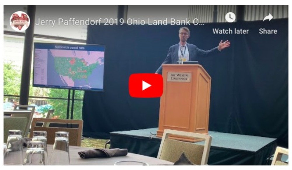
The OLB Conference is an annual meeting of land banks that convene from all over Ohio to learn about best practices and policy changes that directly affect their work - hosted by our partners at the Western Reserve Land Conservancy - https://www.wrlandconservancy.org/olbc2019/
Watch Jerry's keynote from the event, about all things Loveland, Landgrid Products, and the incredible USPS vacancy data:
Its conference season! Jerry is also speaking at the panel this week at the Center for Community Progress’ Reclaiming Vacant Property Conference in Atlanta. If you are attending the RVP this year, please let us know. Jerry, Nick & Sahana from our team will be there and they would love the opportunity to catch up with you!
Well, that brings us to the end of the October Newsletter! Stay tuned with us for announcements on building footprints & other updates! We are cracking away to close the year on a high note!
Please make the most out of this amazing, albeit short lived Fall weather and might we add - please make the most out of our Fall promotions! Let us know if you are interested in taking us up on any of the above discounts. Just holler at team@landgrid.com. You know we are a super friendly team and we will get in touch with you right away!.
Until then, enjoy some yummy fall soups & halloween candies!
We’ve got a big new update for you. Like, a REALLY BIG one!!!
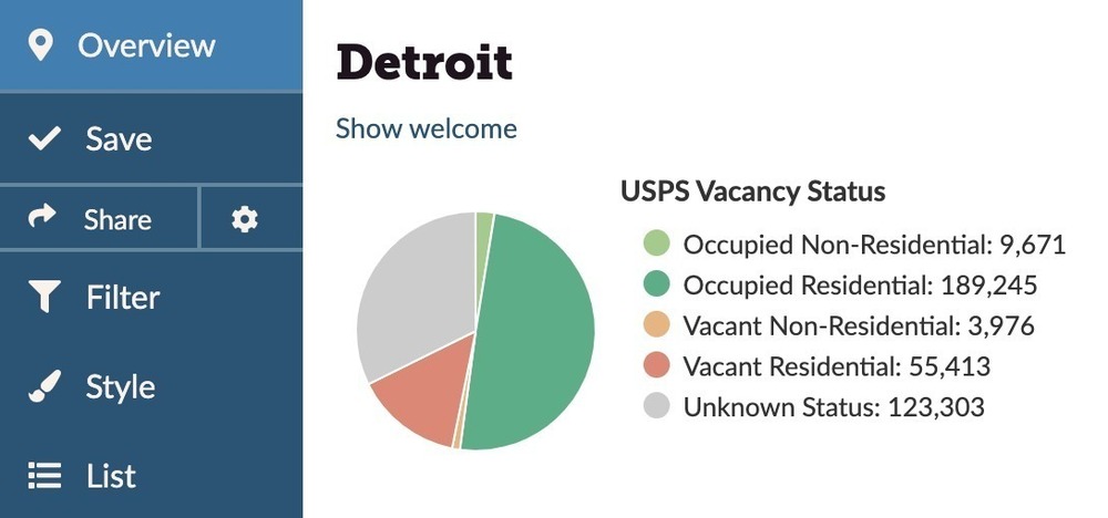
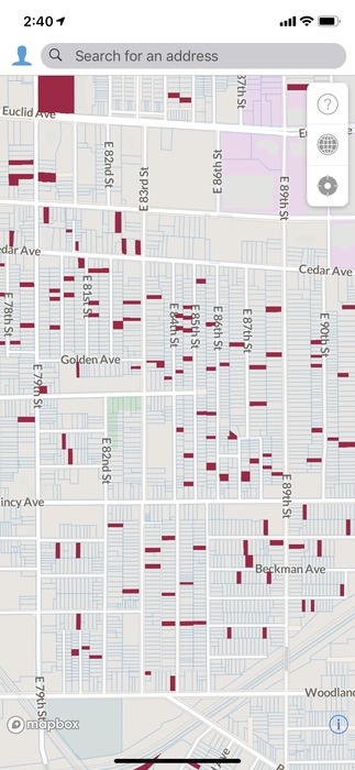
Launching today, Nationwide USPS Residential & Vacancy Data! We have integrated a powerful nationwide vacancy dataset from the United States Postal Service.
Now you can easily see vacant properties of any zoning type in any neighborhood or city, as well as all residential properties regardless of vacancy.
We've built this powerful dataset from United States Postal Service data, and we'll be updating it frequently throughout the year. The data is available on our platform right now for Pro and Enterprise customers, so you can visit landgrid.com to check it out. If you don't have a Pro account yet you can sign up here. The data can also be licensed for use outside of our website in your own app or database.
We're excited to provide this vacancy data nationwide at the parcel level, something that to our knowledge has not been done before. While aggregated USPS vacancy data is a widely-accepted indicator and has been used in academic studies and research since at least 2010, there has rarely been a way to crack that data open and see how those aggregations have been made, or how reliable the data is. While we know that the data is not perfect - and we hope that you get in touch with us to share your findings, so we can refine this dataset going forward - the Loveland team feels that this is an important tool for our friends and partners to have, and a revolutionary step forward in understanding the property dynamics in our communities.
What does this mean for each one of our solutions, you ask???
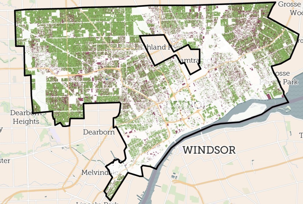
Landgrid Mapping Platform - Pro & Enterprise If you’re a Pro or Enterprise member of landgrid.com you now have an easy way to see all residential parcels, nationwide, as well as an indicator of vacancy across all parcels that have buildings, whether they’re residential, commercial, or industrial.
This is data we’ve cleaned, organized, and integrated from the US Postal Service to make it our own and bring it to life for you with our other parcel data.
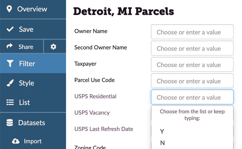
It means that you can now go to your city or the places you’re interested in and use the Filter function to show all residential properties and/or Filter to show all vacant buildings, alone or in combination with any other characteristic you’re looking for.
Surveying Vacant Properties with the Landgrid App: And for those of you who work on tracking and addressing vacant property in your cities, you can now load the vacant properties into a survey so you can quickly visit and document them in the field. Check out our USPS Data Page to learn how to load vacant properties onto your app for surveying - https://landgrid.com/vacancy &https://support.landgrid.com/articles/usps-data/
This is all now completely live on landgrid.com, and we’re excited to show it off at the upcoming OhioLand Bank Conference in Cincinnati where our CEO, Jerry Paffendorf, will be giving a keynote presentation, and at the Center for Community Progress’ Reclaiming Vacant Property Conference in Atlanta where Jerry will be on a panel.
If you don’t have a LandgridPro account yet you can sign up here for only $10/month or $100/year. If you or your organization are working on a project that needs support, multiple users, or custom work from our team, check out our Enterpriseofferings here which typically range from $10,000 and up depending on your needs.
Landgrid Parcel Data: This data can also be licensed for use in your own system along with our other nationwide parcel data. Write to us at parcels@landgrid.com if you are interested.
Note: All data has limitations and imperfections, but this is an incredible dataset for you to make use of. So please be aware that there might be some discrepancies with this data occasionally. Some of the limitations and imperfections here include not yet being able to match every address to every parcel perfectly; the vacancy indicator may apply to one or a few units within an otherwise occupied multi-unit dwelling; you are asked not to use the data for direct mail commercial marketing campaigns, and the USPS data will not download in a CSV export for Pro customers. (though after you Filter you can export a CSV of those properties minus the USPS column). Learn more about this data & its limitations here - https://landgrid.com/vacancy
We will be working to ground-truth and improve the accuracy of this data moving forward. If you have observations about the USPS data in your area which you'd like to share with us in an effort to refine and improve the information, please contact Nick: nick@landgrid.com.
Those things aside and in mind, this is a huge leap for parcel-kind! While standardized nationwide zoning is hard, you now have a uniform nationwide indicator of what is residential (alongside of the other local zoning information we have). Similarly, while understanding nationwide vacancy is hard, you now have an out-of-the-box solution to understand the scale of potential vacancy and jumpstart your planning processes.
Please parcel responsibly, and reach out to us at team@landgrid.com if we can do anything for you.
TORONTO, ON - Aug 28, 2019 — ThinkData Works, Inc. (ThinkData) has brokered a data partnership with Loveland Technologies (Landgrid.com) to make detailed information on over 144 million parcels available through the Namara Data Marketplace, enabling high-accuracy analysis and visualizations.
Loveland Technologies is based in Detroit, Michigan, and works with governments, developers, neighbourhood groups and individuals to present property information in clear, actionable ways. By connecting to parcel data from thousands of counties across the United States and standardizing the output to a common feed, Loveland has developed a best-in-class parcel database that covers over 95% of the US population and 3200 counties.
144 million parcels and counting of parcel shapes, ownership & assessments
USPS residential & vacancy data
2661 active counties
2,163 counties with ownership data
2,408 counties with address data
Loveland works with professionals in multiple industries and areas of focus, including GIS and geocoding, energy and infrastructure, real estate and site selection, conservation and agriculture, insurance and disaster relief, machine learning and modelling, and education and policy. Accessing quality data about the underlying land grid of parcel shapes, ownership, and assessments is fundamental to all businesses and research projects that rely on property and spatial information.
“Everything that isn’t a street or a sidewalk exists on a parcel of land with a legal shape, address or ID, owner, and other fundamental property characteristics. Landgrid.com brings truly comprehensive nationwide land parcel data to a wider audience by being friendlier and more affordable than people are used to finding, without sacrificing quality and innovation,” says Loveland Technologies CEO Jerry Paffendorf. “Our channel partnership with ThinkData Works will help us reach even more people and companies who want to put this foundational dataset to work for their customers and communities.”
Lewis Wynne-Jones, Head of Data Acquisition for ThinkData, says, “ThinkData’s background in open data means we’ve seen a lot of parcel data from counties across the US. We knew at the time that there was a massive opportunity for someone to gather this data together and turn it into an actionable product. The product that Loveland has put together makes this data easily accessible for the first time.”
About ThinkData Works ThinkData Works, Inc. (ThinkData) is a Toronto-based company founded in 2014. ThinkData created Namara - a data management platform that enables businesses to access, manage, enhance, and integrate data in order to develop new products and gain insight. Built for data professionals, Namara is a data refinery for the enterprise, designed to let organizations and individuals access high-value data in standard formats. To learn more, please visit Namara and follow us @ThinkDataWorks and on LinkedIn.
About Loveland Technologies Loveland Technologies is one of the leading providers of nationwide parcel data covering 95% of the American population and across all 50 states. We tirelessly assemble and refresh a nationwide dataset of more than 144 million parcel boundaries and records covering 95% of Americans, and weave it all into a standardized format that makes it easy to work with. We are very transparent with our data sources & parcel currency and only acquire data straight from local counties & public data sources.
Many of you asked to see the "2019 Wayne County Tax Foreclosure Auction" data on the Landgrid platform. We made it available a few days ago.
Note that Loveland has its headquarters in Detroit and spends a lot of time and resources tracking tax foreclosure, helping people avoid tax foreclosure, pointing out how destructive the tax foreclosure process and auction have been to Detroit (as you can see in this VICE News HBO video that includes our CEO discussing the problems —
), and advocating for policies that will improve the situation.
We ask that if you participate in the auction that you do so humanely as many properties are occupied. We do not support the auction as it’s currently conducted, but we share it because we believe it’s important for people to see what is happening.
Below are the full set of instructions to access the data & layer on the Landgrid Platform when signed:
1) Click the Datasets tab on the left sidebar. 2) In that Datasets panel which opens once you click, you'll see an 'Import Data' bar and below that, three options: Mine/Public/All. Click 'Public'. 3) Scroll down through the datasets until you see "2019 Wayne County Tax Foreclosure Auction", and click on it when you do. 4) Click the blue 'add to project' button, and you'll see it appear on your map.